Spanning 27 kilometers across the mountainous border of Iwate and Akita prefectures, the Hachimantai Aspite Line (八幡平アスピーテライン) in Towada-Hachimantai National Park (十和田八幡平国立公園) is widely considered the most scenic drive in the Tohoku region. This toll-free highway offers sweeping views of Mt. Iwate, winding past alpine wetlands, panoramic observation decks, and volcanic peaks. Whether you are driving between towering 8-meter walls of ice during the spring Snow Corridor (mid-April to mid-May) or taking in brilliant crimson foliage in autumn (late September to October), navigating this scenic route is an unforgettable road trip experience. This complete guide covers essential driving details, top observation stops, public transit options, and plant-based dining advice for your journey.
The Attractions Along Hachimantai Aspite Line
- Quick Travel Planning Overview
- Best Time to Visit the Aspite Line (Seasonal Highlights)
- Essential Driving & Logistics Information (Directions, Road Closures, Rental)
- Car Rental & Navigation Guide
- Public Transport Alternatives: Getting There Without a Car
- Top Stops Along the Hachimantai Aspite Line
- Gozaisho Wetland (御在所湿原): Scenic Marshland Walk
- Hachimantai Aspite Line Observation Deck (八幡平アスピーテライン展望所): Panoramic Mountain Views
- Genta-Iwa Observation Deck (源太岩展望台): Volcanic Rock Lookout
- Kuroyachi Marsh (黒谷地湿原): Alpine Flora & Nature Trail
- Hachimantai Mikaeri Pass (見返峠): High-Altitude Mountain Lookout
- Hachimantai Mountaintop Rest House (八幡平山頂レストハウス)
- Ōbukazawa Observation Deck (大深沢展望台): Sunset & Valley Viewpoint
- Essential Vegetarian & Vegan Guide for the Hachimantai Aspite Line Drive
- Hachimantai Aspite Line FAQ
Quick Hachimantai Aspite Line Travel Planning Overview
| Feature | Key Details |
| Location | Towada-Hachimantai National Park (Iwate to Akita Prefecture border) |
| Route Distance | 27 km (16.7 miles) winding mountain road |
| Toll Fee | 100% Free (No toll charges) |
| Driving Time | 40–60 minutes (continuous) | 2–3 hours (with scenic stops) |
| Winter Closure | Early November to Mid-April (annual seasonal closure) |
| Peak Seasons | Spring (Snow Corridor: Mid-April to Mid-May) | Autumn (Peak Koyo: Late Sept to Mid-Oct) |
| Highest Point | Hachimantai Mikaeri Pass / Summit Rest House (1,560 m / 5,118 ft) |
| Nearest Main Hub | JR Morioka Station (~1 hr 50 mins via direct bus) |
| GPS / Map Code | Hachimantai Mountaintop Rest House: 0195-78-3500 | MapCode: 435 881 740*88 |
Best Time to Visit Hachimantai Aspite Line: Snow Corridor vs. Autumn Foliage

If you think the road is just another highway you can sleep through as a passenger, that is definitely NOT the case! From fresh green in spring to vivid color in autumn, the driver will have a hard time keeping their attention on the road with surroundings this beautiful.
Timing your drive along the Hachimantai Aspite Line depends on whether you want to experience towering walls of ice or vivid autumn mountain colors.
- Spring (Mid-April to Mid-May) — The Snow Corridor (Yuki no Otoshiro): When the road reopens after winter closure in mid-April, snow plows carve a pathway through deep drifts, creating snow walls up to 8 meters (26 feet) high lining both sides of the road. Peak snow wall height is in late April. By late May, the snow melts enough to uncover the famous Hachimantai Dragon Eye (Kagami-numa) near the summit.
- Autumn (Late September to Mid-October) — Peak Fall Colors: The landscape transforms into brilliant shades of orange, crimson, and gold. Autumn foliage starts at higher elevations near the summit in late September and moves down toward Gozaisho Wetland by mid-October.
Tip: Late spring (late May) and summer offer fresh green alpine foliage, ideal for trekking, but spring and autumn remain the prime seasons for scenic driving.
Important: The Hachimantai Aspite Line is closed in winter from early November due to heavy snow and reopens around mid-April the next year.
Driving Details: Distance, Routes, and Time
Planning your drive across the Hachimantai Aspite Line is straightforward:
- Road Distance: 27 km (16.7 miles) crossing the border between Iwate and Akita Prefectures.
- Toll Fees: 100% Free (No tolls).
- Driving Time: 40 to 60 minutes continuously, though you should budget 2 to 3 hours to stop at observation decks and take short walks.
- Starting Points:
- Iwate Side (Matsuo-Hachimantai IC): Most popular starting route. Easy access via the Tohoku Expressway, passing Gozaisho Wetland on the way up.
- Akita Side (Kazuno / Hanawa IC): Connects smoothly with Lake Tazawa and Towada-Hachimantai National Park to the west.
- Seasonal Closures: Closed to all traffic from early November to mid-April. During early spring (April–May), the road may close overnight or during bad weather due to freezing conditions.
Car Rental & Navigation Guide
Renting a car is the best way to explore the Aspite Line at your own pace.
- Where to Rent:
- JR Morioka Station: The main transit hub. Major rental outlets (Toyota Rent-a-Car, Nippon Rent-A-Car, Times Car Rental) are located outside the East and West exits.
- Hanamaki Airport (HNA): Ideal if you fly directly into Iwate.
- GPS & Navigation: Enter the map code or phone number for the Hachimantai Mountaintop Rest House (
0195-78-3500/ MapCode:435 881 740*88) into your car’s GPS. English GPS systems are widely available—request one when booking. - ETC Card & Highways: While the Aspite Line itself is free, reaching it via the Tohoku Expressway requires toll payment. Rent an ETC (Electronic Toll Collection) card from your rental company to use the fast lanes at highway gates.
- Driving Conditions: standard tires are sufficient once the road opens in mid-April. However, drive cautiously early in the morning during spring, as meltwater can refreeze into black ice.
Public Transport Alternatives: Getting There Without a Car
If you don’t drive, you can still reach the Aspite Line summit using public transit during the operational season.
- Main Bus Route: Iwate Kenkoku Bus operates direct services from JR Morioka Station (East Exit, Bus Stop No. 3) to the Hachimantai Mountaintop (Hachimantai Chōjō).
- Travel Time: ~1 hour 50 minutes one way to the summit rest house.
- Operating Window: Regular buses run daily from mid-April through early November (suspended during winter closure).
- Seasonal Bus Passes: Look for the Hachimantai Shizen Sansaku Bus pass or regional Tohoku bus discount passes available at Morioka Station tourist info centers to save on round-trip fares.
Top Stops Along the Hachimantai Aspite Line
Driving along the Hachimantai Aspite Line offers far more than just sweeping tarmac. It is a journey through alpine marshes, panoramic mountain lookouts, and natural spring waters. Winding from the base in Iwate up to the 1,560-meter summit at Mikaeri Pass, the route features several scenic turnouts and walking trails worth adding to your itinerary. Below are the key attractions to stop at along your drive, ordered as you ascend from east to west.
Gozaisho Wetland (御在所湿原): Scenic Marshland Walk

Close to the entrance of the Hachimantai Aspite Line is the Gozaisho Wetland, a treasure trove of alpine plants. In spring, a 15-minute walk from the car park at the promenade trailhead, you will see various flowers blooming along the track!
The 90-minute trekking course around the Gozaisho-Numa Pond (御在所沼) and the Goshiki-Numa Pond (五色沼) is most scenic when the grass turns red from late September to early October!
If you visit the Goshiki-Numa Pond regularly, you will notice that the color of the pond changes throughout the year. In summer, it is a beautiful cobalt blue, but in autumn it takes on a golden hue!
To get to Gozaisho Wetland by public transport, you can catch either the regular bus services or the Hachimantai Shizen Sansaku Bus (八幡平自然散策バス) from JR Morioka Station’s (盛岡駅) east exit’s bus stop no. 3.
For more information, please refer to our How to Get to Hachimantai article.
Hachimantai Aspite Line Observation Deck (八幡平アスピーテライン展望所): Panoramic Mountain Views
Hachimantai Aspite Line Observation Deck is a scenic location in the middle of the Aspite Line. It has a lookout that offers views of ridgelines and mountains such as Mt. Iwate (岩手山) and Mt. Akita-Komagatake (秋田駒ケ岳). Depending on the weather, you might even be able to see the sea of clouds!
Genta-Iwa Observation Deck (源太岩展望台): Volcanic Rock Lookout
Driving a bit further southwest, you will see this gigantic rock at the side of the road. Park in the parking space directly opposite the rock to get the amazing view in the second photo of the Instagram post!
Kuroyachi Marsh (黒谷地湿原): Alpine Flora & Nature Trail
Driving further up to the summit of Mt. Hachimantai, you will pass through the Kuroyachi Marsh.
If you have the time to spare, leave your car at the car park and take a 10-minute walk to the observation area. The wooden tracks are again surrounded by alpine plants that you won’t be able to see in your daily life!


Somewhere along the promenade, there is a spot called “Kuma-no-Izumi (熊の泉)” where fresh spring water flows out. This spring water comes from melting winter snow and is not only safe to drink but also quite delicious!
For those who love hiking, follow the wooden tracks and pass the observation area. You can hike all the way up to the summit of Mt. Hachimantain in around 2 hours.
To get to Kuroyachi Marsh by public transport, you can catch either the regular bus services or the Hachimantai Shizen Sansaku Bus (八幡平自然散策バス) from JR Morioka Station’s (盛岡駅) east exit’s bus stop no. 3.
For more information, please refer to our How to Get to Hachimantai article.
Hachimantai Mikaeri Pass (見返峠): High-Altitude Mountain Lookout
At an altitude of 1,560 meters, Hachimantai Mikaeri Pass boasts more than just a breathtaking view. It is also home to the Hachimantai Mountaintop Rest House (八幡平山頂レストハウス), making it a convenient place to grab food and get handy information about Towada-Hachimantai National Park.
Here, you can also catch a glimpse of a beautiful sunrise such as the one shown in the Instagram post.
Hachimantai Mountaintop Rest House (八幡平山頂レストハウス): Trailhead & Amenities
- Opening Hours: 9 am to 5 pm from mid-April to early November
- Facilities: Hachimantai information corner, toilet, resting space, souvenir shops, and restaurant (please note their broth and most sauces contain fish meat extracts. To confirm with the restaurant staff, please utilize the phrases in our Essential Japanese Phrases for Vegetarian article.

Tip: The car park at the Rest House isn’t free. If you want to save some money, there is a free car park not too far from the Rest House.
Ōbukazawa Observation Deck (大深沢展望台): Sunset & Valley Viewpoint
A few-minute drive west from Hachimantai Mikaeri Pass, the Ōbukazawa Observation Deck offers another panoramic view of the surrounding mountains.
And how about getting some ice cream from this old lady?
Discover the Attractions in Other Parts of Hachimantai

Now that you know the best route to get to the summit, it is time to discover the sightseeing spots at the top of the mountain. One of the most fascinating natural wonders at Hachimantai is the scenery called Dragon Eye, which you can see if you visit the national park from late May to early June each year!
Refer to our Hachimantai article for more details!
Essential Vegetarian & Vegan Guide for the Hachimantai Aspite Line Drive
Exploring the mountainous region of Towada-Hachimantai National Park offers incredible scenery, but plant-based dining options directly along the Aspite Line are very limited. Most rest stops and mountain huts in rural Iwate rely heavily on dashi (bonito/fish stock) in soups, noodles, and sauces.
To ensure a stress-free trip, use this guide to plan your meals before heading up the mountain.
Dining at the Summit (Hachimantai Mountaintop Rest House)
Located at the highest point of the drive (1,560m altitude), the Hachimantai Mountaintop Rest House (八幡平山頂レストハウス) is the primary stop for food, drinks, and rest.
- Dietary Reality Check: The restaurant menu primarily features regional specialties like Soba, Udon, and Ramen. Almost all noodle broths and dipping sauces here contain fish extract (dashi).
- Accidentally Vegetarian / Vegan Options:
- Miso-Dengaku (味噌田楽): Grilled konjac or tofu skewers coated in sweet miso paste (check that no fish powder is sprinkled on top).
- Baked Sweet Potatoes & Fresh Produce: Seasonal stalls outside often sell baked sweet potatoes (Yaki-imo) or local apples/berries.
- Language Tip for Ordering:“Dashi ni sakana ya niku wa tsukawatte imasu ka?”(Does the broth contain fish or meat extract?)
Where to Stock Up Before the Drive (Morioka & Base Towns)
Because options on the mountain are sparse, the best strategy is to grab a packed lunch (bento) or snacks before ascending.
1. Starting from Morioka City (Recommended)
Morioka has the best vegetarian-friendly infrastructure in the prefecture:
- Dine or Pick Up a Lunch Box: Before heading out of the city, stop by one of the plant-based eateries featured in our guide on Where to Find Vegan-Friendly Restaurants in Morioka to grab a meal or order a portable lunch box.
- Convenience Store Picks:
- Salted Onigiri (Shio-musubi): pure rice without filling.
- Kombu (Kelp) or Umeboshi (Pickled Plum) Onigiri: check labels for hidden fish stock in the seasoning.
- Edamame, Roasted Chestnuts, and Tofu Bars.
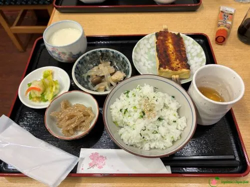
2. Base of the Mountain (Matsuo-Hachimantai Area)
- Michi-no-Eki Matsuo-Hachimantai (Roadside Station): Before starting the steep drive up the Aspite Line, stop at this roadside station. You can find fresh local fruit (apples, grapes, peaches depending on season), steamed corn, and local vegetable snacks.
Quick Packing Checklist for Plant-Based Drivers
Before setting off on the 27 km drive, pack these items in your rental car:
- Portable Snacks: Energy bars, dried fruit, mixed nuts, and soy milk boxes from Morioka.
- Travel-Sized Soy Sauce / Vegan Tsuyu: Essential if you want to enjoy plain tofu or noodles at mountain rest stops safely.
- Emergency Bento / Onigiri: Pick up 2–3 vegan-friendly rice balls before leaving the city in case mountain food stalls are closed or sold out.
Hachimantai Aspite Line FAQ
Is the Hachimantai Aspite Line open year-round?
No. The Aspite Line closes for winter from early November until mid-April due to heavy snowfall. During the early spring opening period (mid-April to early May), temporary evening closures may occur if road freezing is predicted.
Do I need to pay a toll to drive the Hachimantai Aspite Line?
No, the 27 km mountain drive is free and has no toll booths. However, reaching the area via the Tohoku Expressway may incur standard highway tolls.
How long does it take to drive the Aspite Line?
Continuous driving takes about 40 to 60 minutes. However, you should budget 2 to 3 hours to enjoy observation decks, take short boardwalk walks at wetlands, and stop at the summit rest house.
Can I see the Hachimantai Dragon Eye directly from the road?
No. You must park at the Hachimantai Mountaintop Rest House and take a 15-to-20-minute walking trail to Kagami-numa pond. The “Dragon Eye” phenomenon occurs when the snow thaws between late May and early June.
Is it easy to find vegetarian or vegan food along the drive?
Options on the mountain are extremely limited, as most noodle broths (dashi) contain fish extract. We highly recommend buying plant-based snacks or lunch boxes in Morioka City or at roadside stations (Michi-no-Eki) before heading up.
Combine Your Visit to Hachimantai with Appi Kogen Nearby
If you want to extend your Iwate road trip into the highlands, combine your drive with a visit to neighboring Appi Kogen.
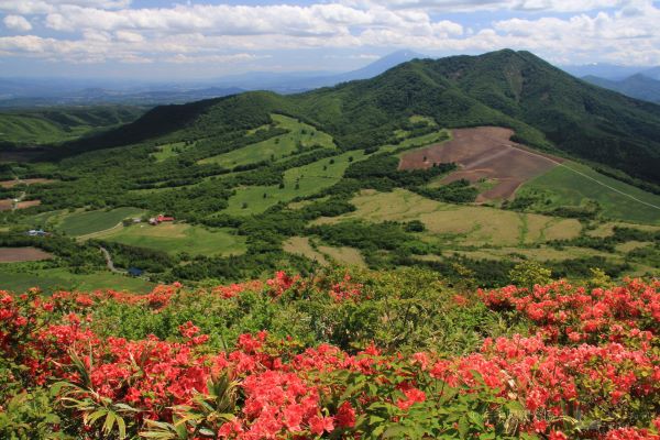
Appi Kogen is an idyllic plateau in western Iwate Prefecture. It is great for a relaxing walk from spring to autumn. When the region transforms into a winter wonderland, many come to Appi Kogen to ski or snowboard on its high-quality snow (Appi Ski Resort is said to be comparable to resorts in Hokkaido)!
Read our detailed guide to Appi Kogen to discover seasonal outdoor activities, summer trekking, and winter ski resorts.

Start Your Journey from Morioka, Iwate’s Prefecture
Most travelers begin their Aspite Line journey from Morioka Station. If you are starting your road trip from Morioka, plan to spend some time exploring the city before heading into the mountains.
From historic sites and ironware shops to famous local noodle spots, check out our guide on what to do and see in Iwate’s capital city, Morioka to build the ultimate urban itinerary before your drive.