The Hakusan Shirakawa-go White Road (白山白川郷ホワイトロード) is the ultimate scenic drive between Kanazawa and the historic village of Shirakawa-gō, but it is far from a standard highway. It is a specialized, automobile-only tourist route packed with sheer cliff drop-offs, free open-air footbaths, and iconic spots like the 86-meter Fukube Falls. Because the 33.3 km toll road cuts through an isolated national park, a successful road trip here requires knowing the rules before you go. From strict vehicle restrictions and cash-only toll gates to the complete lack of cell service and plant-based food options, here is your ultimate safety and survival guide to conquering the White Road stress-free.
All You Need to Know About Hakusan Shirakawago White Road
- Hakusan Shirakawa-gō White Road’s Accessible Period
- Exploring Hakusan Shirakawa-gō White Road Without a Car
- Chūgū Resthouse (中宮レストハウス)
- Hakusan Nature Conservation Center Chūgū Museum (白山自然保護センター(中宮展示館))
- Shiritaka Falls (しりたか滝) and Kamasokono Falls (岩底の滝)
- Jadani Bridge (蛇谷大橋) and Kamoshika Falls (かもしか滝)
- Snake Valley Park (蛇谷園地), Oyadaninoyu Natural Bath (親谷の湯), and Ubagataki Falls (姥ヶ滝)
- Mizunori Falls (水法の滝)
- Fukube Falls (ふくべの大滝)
- Kunimi Observatory (国見展望台)
- Hakusan Observatory (白山展望台)
- Tsuga no Mokudai (栂の木台) and Fukubedani Gardens Observatory (ふくべ谷上園地展望台)
- Sanpōiwadake Parking Lot (三方岩駐車場) to Mt. Sanpōiwadake (三方岩岳)
- Shirakawa-gō Observatory and Buna no Komichi Beech Route (白川郷展望台・ブナのこみち)
- Rennyo Tea House and Information House (蓮如茶屋・情報ハウス)
- Vegetarian & Vegan Survival Guide for the Hakusan White Road
- Crucial Traffic Regulations & Vehicle Restrictions at Hakusan-Shirakawago White Road
- The “No Signal” Warning: Navigating the Mobile Dead Zones
- The Fall Foliage Season at Hakusan Shirakawa-gō White Road
- What Are the Best Stops Along the Hakusan White Road?
- Hakusan Shirakawa-go White Road FAQ
Refer to the Official Website for the map of the entire road.
Important:
☛ Expect no mobile reception in the deep gorges.
☛ Drone Ban: Flying, operating, or photographing with a drone anywhere within the Hakusan-Shirakawago White Road boundary is strictly illegal. Park rangers enforce this rule aggressively to protect the local wildlife and ensure driver safety.
Hakusan Shirakawa-gō White Road at a Glance
The 33.3-km Hakusan Shirakawa-gō White Road starts from the foot of one of the Top Three Sacred Mountains in Japan – Mt. Hakusan (白山), which connects you with Shirakawa-gō. The road is open entirely from early June to early November each year. Not only is there a lookout that bestows a clear view of Shirakawa-gō from above, but the Hakusan Observation Deck is also the best spot to admire the spectacular main peaks of Mt. Hakusan!
- Gozengamine (御前峰) at 2,702 meters
- Onanjimine (大汝峰) at 2,684 meters
- Kengamine Peak (剣ヶ峰) at 2,677 meters
At the same time, you will be enjoying the fresh greenery in spring and autumn leaves, coupled with waterfalls and a sea of virgin beech forest spread out below you! If you love hiking, a couple of mountain trails offer some spectacular scenic views (^_-)-☆.
Depending on your itinerary, you can enter Hakusan Shirakawago White Road from the exits in either Ishikawa or Gifu Prefecture. The attractions below assume you start your trip from Chūgū Toll Gate (中宮料金所) in Ishikawa Prefecture.
Hakusan Shirakawa-go White Road’s Accessible Period
The toll road is only accessible for parts of the year due to heavy snowfall in the area.
- From June to August, it is open from 7 am to 6 pm.
- From September to November, it is open from 8 am to 5 pm.
- The toll road exits will close an hour after the time above, so be sure you are out of the Hakusan Shirakawago White Road before then, or you will be trapped until the following day.
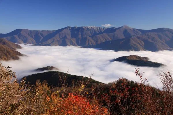
- From the end of September to late October, the road will open an hour earlier at 7 am to allow visitors to access the amazing “sea of clouds” scenery from Sanpōiwadake Parking Lot (三方岩駐車場) and Shirakawa-go Observatory (白川郷展望台).
- This natural phenomenon is most commonly observed between mid-September and mid-October each year.
Tip: As the sea of clouds is a natural phenomenon, you are not guaranteed to be able to see it on each visit. One tip to maximize your odds is to check the weather forecast. If the highest temperature during the day before your visit is at least 10 degrees above the lowest temperature, there is a higher chance of having a thick layer of cloud. Note that if it is rainy on the day, you are unlikely to see the sea of clouds.
Hakusan Shirakawa-go White Road’s Toll System & Pricing
Navigating the Hakusan-Shirakawago White Road requires passing through a dedicated, manned toll booth on either end of the pass: the Chūgū Toll Gate (Ishikawa side) or the Magari Toll Gate (Gifu side).
Depending on the size of your vehicle, the following tolls will apply at the toll gate. Tolls are calculated by vehicle class. The toll rate covers all passengers inside the vehicle and grants you full access to all parking lots, trailheads, and observatories along the 33.3 km stretch.
| Vehicle Type | One-Way Toll | Round-Trip Toll | Examples |
|---|---|---|---|
| Standard Car | ¥1,700 | ¥2,600 | Regular rental sedans, SUVs, compact cars |
| Light Car (Kei Car) | ¥1,400 | ¥2,200 | Yellow-plate mini cars, registered Trikes |
| Microbus | ¥5,000 | ¥7,900 | Small tour vans (11–29 passengers) |
| Regular Bus | ¥11,000 | ¥17,600 |
Important: Payment is cash only. They do not accept credit card payments at the moment.
Tips:
☛ If you are staying at one of the onsen ryokans in the areas close to Hakusan Shirakawagō White Road, you might get a discount on the toll. Please check with your accommodation to confirm.
☛ The round-trip ticket is valid for 5 days.
Where are the Toll Gates Located?
- Ishikawa Side (Chūgū Gate): Located along Route 360, just past the Chūgū Onsen area. If you are driving from Kanazawa or Kaga Onsen, this is your entry point.
- From Kanazawa city center, it is a 90-minute drive to the Chūgū Toll Gate (中宮料金所).
- Gifu Side (Magari Gate): Located just outside Ogimachi Village (Shirakawa-go). If you are coming from Takayama or the historic thatched-roof villages, you will enter here.
Exploring Hakusan Shirakawa-go White Road Without a Car
If you can not or do not wish to drive, there are still ways that you can explore this picturesque road by hiring a chartered taxi or joining one of the bus tours.
Hakusan Shirakawago White Road Chartered Taxi
The taxis depart from JR Kanazawa Station (金沢駅). You can choose from two options: a one-way trip to Shirakawago or a return trip to Kanazawa. A taxi can accommodate up to 4 people.
Please book at least a day before your departure date by calling Private Taxi Hakusan kankō (個人タクシー 白山観光) at +81-90-9761-6712 between 7 am and 11 pm. Depending on the booking, they might be able to cater it on the day if you call at least an hour in advance.
- Hakusan Shirakawago White Road Return Course (白山白川郷ホワイトロード折り返しコース)
- The trip will end at Sanpōiwa Parking Lot (三方岩駐車場), which means Shirakawa-go Observation Deck is excluded from this course
- The cost is 18,000 yen + tolls
- The approximate time required is 5 hours
- Hakusan Shirakawago White Road One-way Course (白川郷までの片道コース)
- The trip starts from JR Kanazawa Station and ends at Shirakawago
- The cost is 14,000 yen + tolls
- The approximate time required is 3 hours
Exploring Hakusan Shirakawago White Road With a Bus Tour
There are a couple of bus tours departing from JR Kanazawa Station that you can join. For more information, please refer to the official website of Hakusan Shirakawago White Road.
Chūgū Resthouse (中宮レストハウス)
Chugu Resthouse is the first resting spot on the Hakusan Shirakawago White Road. Light meals are served at the resthouse, but there is no vegetarian menu because the broth used contains non-vegetarian ingredients.
However, their Kinako Ohagi (きなこおはぎ), a traditional dessert with sweetened soybean powder over red/azuki bean rice cake, is the perfect snack to bring along as you explore the scenic road!
If you have plenty of time, you can see if you can find any wild monkeys around Saruko Bridge (さるこ橋), which isn’t too far away from the resthouse. Especially in summer, you are more likely to spot them. They might even be at the resthouse’s car park (´▽`*).
Hakusan Nature Conservation Center Chūgū Museum (白山自然保護センター(中宮展示館))
If you want more information about Hakusan Shirakawago White Road, drop by the conservation center. The staff at the guide corner knows pretty much everything about the scenery along the road and nearby attractions and can answer most of your questions.
You can also take a leisurely stroll to the Jadani Nature Park (蛇谷自然公園), which is less than a 10-minute walk away. A guided tour is sometimes offered for free on weekends and public holidays. Check with the staff to see if it is on before you venture out (=゚ω゚)ノ.
Shortly after the museum, you will get to the toll gate, where the amazing scenery unfolds.
Shiritaka Falls (しりたか滝) and Kamasokono Falls (岩底の滝)

The next car park along the Hakusan Shirakawago White Road is close to Kamasokono Falls. There are three waterfalls around this car park. A one-way trip to the furthest waterfall, Shiritaka Falls, is within a 10-minute walk.
Shiritaka Falls is the first waterfall on the toll road from the Ishikawa Prefecture side. The silk-like white stream that falls on a cliff will show you different faces depending on the viewing angle and the amount of water falling on the day.
Autumn is probably the best season to visit the waterfall, as you will have a bigger chance of spotting a rainbow in the middle of it (^_-)-☆.
The Akachi Falls (赤石の滝) is a really small waterfall that splits into three streams from the top. It is also nicknamed “Shamisen no Taki (三味線の滝)” because the streams resemble the thread of a Shamisen (Japanese guitar).
In spring, the volume of streams falling down Kamasokono Falls is at its highest, making it more exciting when you walk by the waterfall. In autumn, the waterfall can be adorned with wonderful colors with the surrounding foliage. Above the waterfall, a giant zelkova (a type of elm) is said to be over 500 years old.
Jadani Bridge (蛇谷大橋) and Kamoshika Falls (かもしか滝)
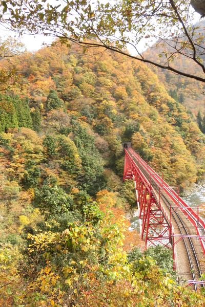
The next notable spot along the road is Jadani Bridge. This bridge, which spans 70 meters and rises 45 meters above the water, is the only bridge across the Jadani River Gorge (蛇谷川峡谷).
Unfortunately, there is no parking near the arch bridge. If you are lucky enough that there are no vehicles behind you, you can drive as slowly as you want while taking in the gorge’s beauty!
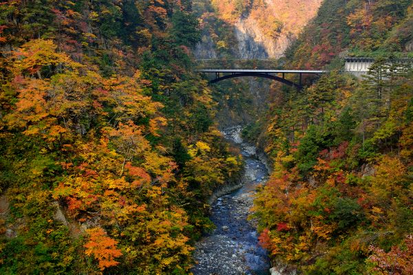
Tip: Shortly after you pass through the bridge, there is a shoulder of the road where you can park temporarily. But just be really careful when you walk back to the bridge, as there is almost no gap between the cliff and the motorway.
Kamoshika Falls is really close to Jandani Bridge and the 4th waterfall along Hakusan Shirakawago White Road. Again, there is no parking lot close by, so you must drive carefully while paying attention to the 5-tiered waterfall.
If you are really lucky, you might spot one of Japan’s fabled wildlife, the Japanese serow. After all, the waterfall got its name from the population of Japanese serows living here (´▽`*).
Tip: The autumn foliage in this area can usually be viewed around late October.
Snake Valley Park (蛇谷園地), Oyadaninoyu Natural Bath (親谷の湯), and Ubagataki Falls (姥ヶ滝)
Just a 2-minute drive from Kamoshika Falls (かもしか滝), you will get to Jadanienchi (Snake Park) Parking Lot (蛇谷園地駐車場). Be sure to hop out of your car here, as one of the Top 100 Waterfalls in Japan is within walking distance!

To get to the waterfall, hike down the staircases from one side of the car park. There is a wooden torii gate with “親谷の湯” inscribed on the attached plaque. The staircases are rather steep, so be careful.
Following the promenade connecting the staircases, the free Oyadaninoyu Natural Bath will be in front of you in around 15 minutes. The beautiful Ubagataki Falls are just beside the hot spring pools. It would be great if they could build an onsen Ryokan here!
There are two onsen pools at Oyadaninoyu Natural Bath. One for your feet and one for indulging your body (if you dare). Anyone can utilize both pools. This is one of the few baths where you can enter with swimmers.
Ubagatani Falls, one of the Top 100 Waterfalls in Japan, is a 76-meter-high waterfall with a 100-meter-wide cascade that gently falls on the rock surface. The name comes from the fact that it looks like the untied hair of an old woman with grey hair (probably from the back).
It may not really matter if you can see an old lady out of the waterfall or not. All you really want to do is enjoy this gorgeous waterfall while dipping your feet into the foot spa!
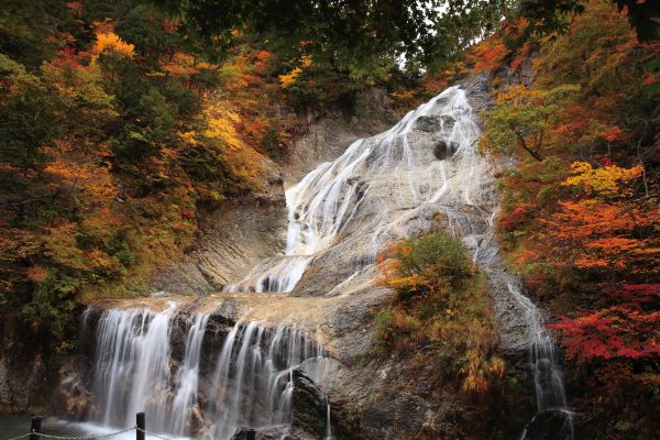
There is an observation deck above the Oyadani Natural Bath if you aren’t a fan of the foot spa. A toilet and a simple female undressing tent are available if you have your swimsuits and want to enjoy the onsen.
On the way back up, the scenery of the surrounding natural beech forests will hopefully alleviate any fatigue…
Oyadaninoyu Natural Bath’s Opening Hours and Access Information
- For the below opening hours, please don’t head down if you are an hour away from the closing time.
- 7 am to 6 pm from June to August
- 8 am to 5 pm from September to November
As a landmark from Gifu Prefecture, the bath is just 4 km away from Fukube Falls (ふくべの大滝). If you are coming from Ishikawa Prefecture, seeing this waterfall means you have already gone past Oyadaninoyu, which is a sign that you should make a U-turn and head back.
Mizunori Falls (水法の滝)
Mizunori Falls, located between Ubagataki Falls and Fukube Falls, can easily be missed since the rockfall protection fence blocks part of the waterfall.
This 60-meter waterfall is the 7th waterfall from the Ishikawa Prefecture side. Mizunori Falls, flowing on top of the rockfall protection fence, is easier to spot if you come from Gifu Prefecture. If you are coming from the opposite direction, your view will be blocked by the rockfall protection fence.
Also, the waterfall is one that you can’t get a picture of in its entirety. But that is okay, as it is one of the least exciting waterfalls in the entire Hakusan Shirakawago White Road (´▽`*).
Fukube Falls (ふくべの大滝 )
Within a 10-minute drive from Snake Valley Park, one of the biggest waterfalls along the Hakusan Shirakawago White Road will suddenly appear. You definitely won’t miss this one, as there is a large parking lot in front of it, with a waterfall-viewing deck opposite the car park.
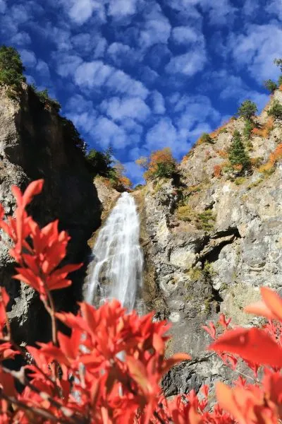
While you can only see a one-tiered waterfall from the viewing deck, it is actually a two-tiered one, which is why it was named “gourd waterfall”.
The waterfall basin is close to the parking lot as well. As water falls from an 86-meter cliff, it sometimes splashes onto the road next to the basin!
Kunimi Observatory (国見展望台)
Kunimi Observatory is the next scenic spot after Fukube Falls. It will give you a panoramic view of Ōnanjimine Peak (大汝峰) and Kengamine Peak (剣ヶ峰), which are two of the three main peaks of Mt. Hakusan (白山).
Even if the weather isn’t ideal and the peaks are clouded when you arrive, it is still a great place to park your car to see Hakusan Shirakawago White Road meandering through the valley and the hillside.
The observatory, located on top of the staircases opposite the car park, is also one of the best spots for viewing autumn foliage along the toll road. At an altitude of 1,100 meters, you can expect the view to be covered by the stunning bright colors of nature around mid-October each year.
Hakusan Observatory (白山展望台)
The next observatory you will visit is the Hakusan Observatory. Like its name, it is the perfect place to admire one of Japan’s Top Three Sacred Mountains, Mt. Hakusan (白山).
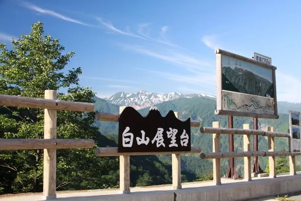
From the observatory, you can expect the best view of Mt. Hakusan’s three main peaks, including the highest peak – Gozengamine (御前峰), at an altitude of 2,702 meters.
With the primeval beech forest spread below you, you can enjoy the fresh greenery in spring or autumn leaves in October while looking out at Mt. Hakusan.
If you want to be at the top of Mt. Hakusan at the far back of the mountain, it isn’t a hard thing to do! A one-way hike takes about 4 to 5 hours, and there are accommodation facilities where you can stay overnight to observe the sunrise at Gozengamine, perhaps!
For more information, refer to our article Mt. Hakusan, which has everything you need to know about the hike (^_-)-☆.
Tsuga no Mokudai (栂の木台) and Fukubedani Gardens Observatory (ふくべ谷上園地展望台)

A 5-minute drive from Hakusan Observatory, there is another car park with Mt. Hakusan in front of you.
And don’t be satisfied just with the scenery from the car park. With a 20 to 25-minute hike, you can get to Fukubedani Gardens Observatory, which will offer you a spectacular panoramic view of the surrounding mountain ranges!

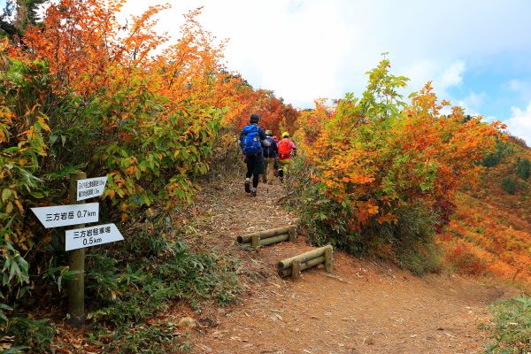
On the way to Fukubedani Gardens Observatory, there is an intersection. One of the paths trailing off from this intersection is the hiking trail to the summit of Mt. Sanpōiwadake (三方岩岳).

From the observatory, a return trip to Sanpōiwadake will take about 2 hours, with a one-way trip from the parking lot of 90 minutes.
The trail is flatter compared to the section from the parking lot to the observatory.
Then, once you are back on the road, you will be passing the prefectural border into Gifu Prefecture via a tunnel.
Sanpōiwadake Parking Lot (三方岩駐車場) to Mt. Sanpōiwadake (三方岩岳)
Around 10 to 15 minutes from Tsuga no Mokudai, you will be at the highest point of the entire Hakusan Shirakawago White Road – the Sanpōiwadake Parking Lot at 1,445 meters above sea level.
The hiking trail from the car park offers a shorter route to the top of Mt. Sanpōiwadake, which stands at an altitude of 1,736 meters. The trail along the mountain ridge isn’t too steep and is suitable for beginners.
A return trip will take around 90 minutes. Apart from Mt. Hakusan, you can sometimes even see the Japanese Northern Alps, such as Mt. Tate (立山) and Mt. Hotaka (穂高岳) if the weather allows!
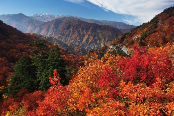
This part of the toll road also welcomes the beautiful autumn foliage, which first appears at the end of September and peaks in early October each year.
Shirakawa-gō Observatory and Buna no Komichi Beech Route (白川郷展望台・ブナのこみち)
Before you get to Shirakawa-gō, how about having a peek at the village from afar?
From the lookout, around a 5-minute walk from the Shirakawago Observatory Parking Lot (you will have to cross the road and climb up a staircase), the Gassho-Zukuri-Style Houses look even smaller than the Lego bricks. In late October and early November, it is the perfect place to snap a photo of the entire village covered by the surrounding autumn foliage!
As mentioned at the beginning of this article, it is one of the spots for an amazing “sea of clouds” scenery. If you are keen, arriving here by 9 am is best.
For those who love trekking, it takes around 2.5 hours from the trailhead that extends from the Buna no Komichi Beech Route to get to Mt. Sanpōiwadake (三方岩岳). Just note that this trail includes steep and/or slippery sections. So prepare your gear accordingly for a safer trip.
At the back of the Shirakawago Observatory is a small trail called Buna no Komichi Beech Route. The loop trail is a 30-minute stroll through a primitive beech forest that is over 300 years old.
The trail isn’t neatly maintained. It is more like a hill road people have trodden on. While the entrance might not be obvious, it is now indicated by a signage board (^_-)-☆.
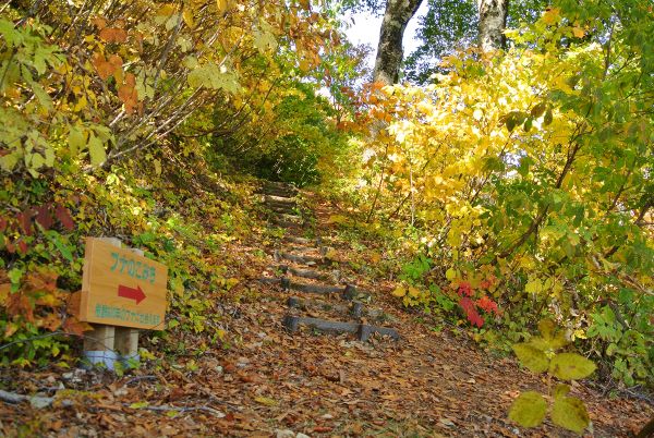
While it may sound like a trail that requires hiking gear, that’s not the case. A pair of sneakers will suffice and suit both children and older people.
Rennyo Tea House and Information House (蓮如茶屋・情報ハウス)
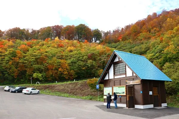
At Shirakawago Observatory Parking Lot, there is a big wooden house. The Rennyo Chaya or Rennyo Tea House differs from the chaya in Kanazawa in that it isn’t a place where you will find Geishas and/or Maiko. It is actually a cafe where you will be served non-vegetarian light meals or morning/afternoon tea.
The small Information House is next to the tea house, where you can source information about the Hakusan Shirakawago White Road and acquire maps of nearby areas. Perfect to be your first stop if you are entering the toll road from Gifu Prefecture!
To Shirakawa-gō
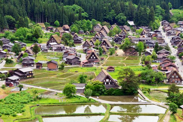
From Rennyo Tea House, follow the signs along the highway. You should be at Shirakawago in around 20 minutes.
And if you are wondering where to go and what to do in this world heritage village, you can refer to our article about Shirakawa-gō!
Vegetarian & Vegan Survival Guide for the Hakusan White Road
Let’s be completely honest: the Hakusan-Shirakawago White Road is a visual feast, but for plant-based travelers, it is a culinary food desert. The isolated mountain terrain means that the few rest stops along the 33km pass heavily rely on local river fish (Iwana) and wild game.
If you are a strict vegetarian or vegan, you cannot roll up to the rest houses expecting a standard plant-based menu. Here is exactly what you need to know to navigate the route without going hungry.
⚠️ Warning: There are absolutely zero convenience stores (Konbini) along the White Road. Once you pass through the toll gates on either the Ishikawa or Gifu side, you will not see a Lawson, 7-Eleven, or FamilyMart for the next 2 to 3 hours.
How to Plan Your Plant-Based Road Trip
To fully enjoy the waterfalls and observatories without a rumbling stomach, use these two travel strategies:
1. Pack a “Mountain Bento” Ahead of Time
Your safest and most relaxing option is to pick up a meal before you start ascending the mountain pass.
- If starting from the Ishikawa (Kanazawa) side: Stop by Kanazawa Station’s food halls. You can easily assemble a picnic with macrobiotic-friendly macro-delis, vegan-friendly Inari sushi, or fresh fruit.
- If starting from the Gifu (Takayama/Shirakawa-go) side: Grab food in Takayama city or the convenience stores outside the historic village before heading to the toll gate.
- At any 7-Eleven or Lawson (near the port/station):
- Onigiri (Rice Balls): Look for Ume (Pickled Plum) rice balls.
- Snacks: Edamame, salt-flavored potato chips, or mixed nuts.
- Refer to HERE for a list of vegan food you can get at convenience stores.
2. Reward Yourself in Shirakawa-go (Ogimachi Village)
If your road trip ends on the Gifu side in Shirakawa-go, you can enjoy the local cuisine, Hoba Miso at one of the vegetarian-friendly restaurants in the traditional village. You will find local, naturally vegetarian street snacks to tide you over until dinner:
| Local Snack | What It Is | Vegetarian Safe? |
|---|---|---|
| Gohei Mochi | Pounded rice cake on a stick, grilled with a thick sweet-savory walnut, sesame, and miso paste glaze. | Yes! (Always double-check that no fish dashi was mixed into the miso, but traditionally it is plant-based). |
| Tochi Mochi | A local specialty rice cake made from Japanese horse chestnuts harvested from the surrounding mountain forests. | Yes. Usually served sweet or alongside green tea. |
| Mitarashi Dango | Chewy, grilled rice dumplings coated in a sweet soy sauce glaze. | Yes. A great, quick energy boost. |
Crucial Traffic Regulations & Vehicle Restrictions at Hakusan-Shirakawago White Road
Because the Hakusan-Shirakawago White Road snakes through pristine alpine terrain and features extreme elevation changes, tight switchbacks, and steep cliff drop-offs, local authorities enforce strict safety regulations. Before renting a vehicle or mapping out your itinerary, make sure you comply with these entry rules to avoid hefty fines or being turned away at the toll gate.
🚫 Strictly Prohibited on the Paid Route
If you are planning your trip using any of the following modes of transportation, you will be denied entry at both the Ishikawa (Chūgū) and Gifu (Magari) toll booths:
- Motorcycles & Scooters: All two-wheeled motorized vehicles, including large touring bikes, mopeds, and even motorcycles with sidecars, are strictly banned for safety reasons.
- Bicycles: Cyclists are completely prohibited from entering the toll road section.
- Pedestrians: You cannot walk through the toll road gates or hike along the main vehicle pass. (Walking is only permitted within designated parking zones and specified hiking trailheads).
⚠️ Critical Driving Rules to Keep in Mind
- Speed Limit: The maximum speed limit across the entire route is a strict 30 km/h. The road is designed for slow, scenic cruising, not fast mountain driving.
- No Overnight Parking: Camping, starting fires, or parking your car overnight at any observation deck or parking lot is strictly forbidden.
- Winter Tires: If you are visiting during the final open weeks (late October to November 10th), you generally do not need studless winter tires. If sudden heavy snow falls or the asphalt freezes, the authorities will simply close the entire road down for safety rather than allowing vehicles through with tyre chains. Always check the official live road status before heading out!
The “No Signal” Warning: Navigating the Mobile Dead Zones
Because the Hakusan-Shirakawago White Road cuts directly through the rugged, deep gorges of the Hakusan National Park, cellular mobile reception is practically non-existent for the majority of the 33km drive.
To ensure a smooth, stress-free road trip, you must prepare for this digital disconnect before you start heading up the mountain.
Essential Prep Checklist Before You Drive
- Download Offline Maps: Do not rely on live Google Maps or Apple Maps to track your location along the pass. Before you arrive at the toll booths, open your map app while you still have data and download the entire regional map (covering Kanazawa, Hakusan, and Shirakawa-go) for offline use. Your phone’s GPS will still work offline, allowing you to see which viewpoints are coming up next.
- Set Your Destination Early: If you are using a built-in rental car GPS (Navi), enter the map code or phone number for your final destination (e.g., your Shirakawa-go hotel or Kanazawa Station) before passing the gate. The satellite navigation inside the car will not drop out, even when your phone does.
- Tell Someone Your Schedule: Since you won’t be able to send quick LINE, WhatsApp, or iMessage updates, let someone know when you are entering the road. Let them know to expect a 2 to 4-hour delay before you reappear online on the other side of the mountain.
Emergency Protocol: What If You Break Down?
If your car gets a flat tyre, overheats, or you experience an emergency while in the dead zone, do not panic. The road operators have installed built-in safety measures:
☎️ Yellow Emergency Phones: Look for the bright yellow emergency call boxes located at major parking lots, observatories, and tunnel entrances along the route. These phones connect directly to the toll gate control centers. Even if you do not speak fluent Japanese, lifting the receiver alerts the staff to your exact location, and they can dispatch a patrol vehicle to assist you.
- Regular Patrols: During operating hours, official road patrol cars drive up and down the route monitoring traffic, checking for rockfalls, and looking out for stranded motorists. If you are stuck at a viewpoint, a patrol vehicle is never too far away.
The Fall Foliage Season at Hakusan Shirakawago White Road
The autumn foliage season along the Hakusan Shirakawago White Road starts from early October to early November, depending on the part of the road. The parts of the road at high altitudes will see the foliage change colour from late September, peak in early October, and gradually spread to lower areas.
| Timing | Elevation Range | Key Locations & Landmarks | Foliage Colors & Characteristics |
| Late September | 1,400m – 1,736m | • Mt. Sanpoiwa Summit & Peak Trail • Sanpoiwadake Tunnel (1,440m) | Yellow & Gold Alpine shrubs and birch trees are the first to change at the highest peaks. |
| Early October | 1,200m – 1,400m | • Hakusan Observatory • High-elevation mountain slopes | Rust, Amber & Gold Maple and oak trees begin their peak across the upper slopes. |
| Mid-October | 1,000m – 1,200m | • Mid-elevation viewpoints • Upper canyon trails | Fiery Red & Vibrant Orange The “Golden Window” where the central section of the pass fully blazes. |
| Late October | 600m – 1,000m | • Fukube Falls (86m) • Ubagataki Falls & Footbath • Jadani Gorge arched bridge | Deep Reds & Faded Browns The color front reaches the lowest ravines, deep gorges, and the entry toll gates. |
🍁 3 Insider Tips for Autumn Color Photographers
- Check the Live Koyo Map Daily: Do not guess the conditions. The official operator runs a live, color-coded foliage tracker on their website during October showing exactly which parking areas are at Green, Starting to Change, Peak (Migoro), or Faded. Check this before paying your toll fee.
- Prioritize Jadani Bridge (蛇谷大橋): For the quintessential postcard photograph, park near the Jadani Gorge walking paths. The red and white arched bridge cutting through a massive wall of golden beech trees over the blue river gorge is the most iconic shot on the route.
- Beat the Weekend Tour Buses: Because this road is a prime autumn destination for domestic tourists, tour buses saturate the narrow pass on mid-October weekends. For a serene drive without fighting for parking spaces at the waterfall pull-offs, arrive at the toll gate exactly when it opens at 8:00 AM on a weekday.
❄️ Note on Closures: The road closes strictly for the year on November 10th. If unseasonably heavy snow hits the high passes early in November, the authorities may close the road several days ahead of schedule. Keep your itinerary flexible if traveling in November!
What Are the Best Stops Along the Hakusan White Road?
The 33.3 km stretch is packed with viewing decks, deep gorges, and cascading waterfalls. However, you shouldn’t pull over blindly at every shoulder. To make the most of your driving time, make sure these five absolute highlights are marked on your itinerary map. Refer to Hakusan Shirakawa-go White Road Map for the parking areas.
| Stop & Parking Area | Top Highlight / Feature | Why You Should Stop | Key Travel Tip |
| Fukube Falls (Parking Area P5) | 86-Meter Waterfall | The undisputed crown jewel of the road. Cascades down a bare rock face right next to a sharp hairpin turn. | Depending on the wind, the heavy mist from the waterfall might spray your car as you pass! |
| Ubagataki Falls (Parking Area P4 / Jatani Gardens) | Free Natural Footbath | One of “Japan’s Top 100 Waterfalls.” Features countless streams resembling flowing white hair. | Hike the 15-minute trail down to the valley floor to soak your feet at the open-air Oyadani-no-yu footbath. |
| Mt. Sanpoiwa Peak Trail (Parking Area P10) | 360° Alpine Panorama | Highest parking lot on the pass (1,455m), sitting directly on the Gifu-Ishikawa prefectural border. | Take the moderate 50-minute hike to the summit (1,736m) for views of Mt. Hakusan and the Northern Japan Alps. |
| Hakusan Observatory (Parking Area P8) | Volcanic Peak Views | Offers the ultimate panoramic view of Mt. Hakusan’s three highest volcanic peaks and a virgin beech forest. | This is the very first area on the mountain pass where the autumn foliage turns vibrant gold in early October. |
| Shirakawa-go Observatory (Parking Area P11) | UNESCO Village Bird’s-Eye View | A newly renovated platform located on the Gifu side of the pass, just before the final toll gate. | Provides a unique aerial view looking straight down into the valley over the historic Gassho-zukuri thatched houses. |
Hakusan Shirakawa-go White Road FAQ
Q: When is the Hakusan-Shirakawago White Road open?
A: The road is open seasonally from early June through November 10th. It is completely closed throughout the winter and spring months due to extreme alpine snowfall.
The daily operating hours shift depending on the season:
- June to August (Summer): 7:00 AM to 6:00 PM (Exit gates close at 7:00 PM)
- September to November (Autumn): 8:00 AM to 5:00 PM (Exit gates close at 6:00 PM)
Q: Can I use my Japan Expressway Pass (CEP) or ETC card for the toll?
A: No. Because the White Road is an independent scenic route managed by local forestry corporations rather than NEXCO, it does not accept standard Japanese ETC cards or regional highway tourist driving passes (like the Central Nippon Expressway Pass). You must pay the toll fee (¥1,700 for standard cars) using cash (Japanese Yen) directly at the toll gates.
Q: How long does it take to drive the entire Hakusan White Road?
A: If you drive straight through the 33.3 km stretch without stopping, it takes about 60 minutes. However, to actually enjoy the path, look at the waterfalls, and stop at the observation decks, you should budget between 2.5 to 4 hours for a leisurely road trip.
Q: Is the Hakusan White Road safe for nervous drivers?
A: The road is a fully paved, well-maintained two-lane highway. However, it is an alpine mountain pass with sharp switchbacks, steep drops, and narrow tunnels. The speed limit is strictly capped at 30 km/h to ensure safety. If you stay within the limit and stay alert, it is perfectly safe, but nervous drivers should take it slow and take advantage of the numerous pull-off parking zones.
Q: Can I visit the White Road by public bus?
A: Regular public transit buses do not service the toll road. If you do not plan to rent a car, your best option is to book a seasonal, specialized sightseeing bus tour (such as those operated by White Ring) that depart out of Kanazawa or Takayama during the peak autumn foliage season.
Q: When is the best time to see the autumn leaves (Koyo)?
A: Because of the dramatic 1,000-meter elevation difference across the pass, the autumn colors last for over a month. The foliage typically begins changing at the highest peaks in late September and slowly moves down the valleys, reaching peak vibrant colors throughout mid-to-late October before ending in early November.