High in the volcanic mountains spanning Miyagi and Yamagata Prefectures lies Okama Crater Lake (御釜), one of Tohoku’s most breathtaking natural wonders. Known locally as Goshiki-numa (the “Five-Color Pond”) for the way its vibrant turquoise waters shift shade under changing sunlight, this striking crater lake offers an unforgettable high-altitude escape. Whether you are navigating the sweeping mountain hairpin turns of the scenic Zao Echo Line or taking the Shinkansen and local mountain buses from Sendai or Tokyo, reaching the summit of Mount Zao is a must-do Japanese road trip. This complete travel guide covers exact transit routes, driving tips, seasonal highlights, and essential advice for planning your visit to Okama Crater Lake.
All You Need to Know for Visiting Okama Crater Lake
- What is Okama Crater Lake?
- How to Reach Okama Crater Lake
- Important Travel Notes, Safety & Route Comparisons
- How to Enjoy Okama Crater Lake: Drives, Hikes & Prep
- The Visibility at Okama Crater Lake Is Only 30%? Tips for Spotting the View
- Is Okama Lake Visible Today? How to Check Zao Live Cameras
- The 3 Best Okama Lake Viewpoints
- Zao Summit Rest House (県営 蔵王山頂レストハウス): What to Eat & Buy
- Seasonal Attractions & Trekking Beyond Okama Crater Lake
- Nearby Attractions & Sendai Day-Trip Itineraries
What is Okama Crater Lake?
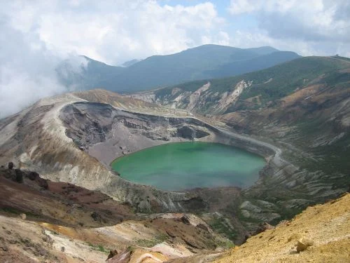
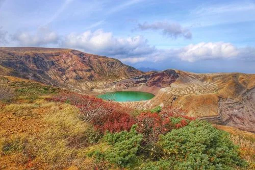
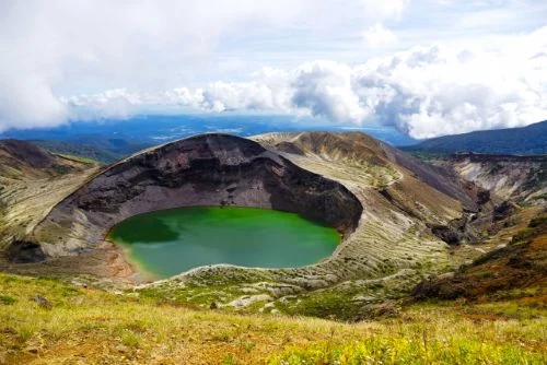
High in the volcanic spine separating Miyagi and Yamagata Prefectures, Okama Crater Lake serves as the crowning jewel of Zaō Mountains (蔵王連峰 , Zaō Renpō), commonly called Mount Zaō. Sitting at an altitude of roughly 1,670 meters (5,480 feet) and bordered by Mount Kattadake, Mount Kuma, and Mount Goshiki, this iconic circular caldera measures roughly 330 meters in diameter and reaches depths of up to 27.6 meters.
Why is it Called “Okama” and “Goshiki-numa”?
- Traditional Cooking Pot (Okama): The lake takes its primary name from its steep, ringed crater walls, which closely resemble a heavy Japanese cast-iron cooking pot (kama).
- The Five-Color Pond (Goshiki-numa, 五色沼): Local communities frequently call the lake Goshiki-numa due to its chameleon-like transformations. Depending on the time of day, angle of sunlight, ambient temperature, and weather, the water shifts fluidly between deep emerald, turquoise, milky jade, and sapphire blue.
- The Sunrise Palette Shift (朝焼けの御釜): The lake earns its “Five-Color” nickname most dramatically at dawn. As the sun rises in the east, the steep crater walls glow vivid orange while the water shifts from deep emerald to shimmering gold. On calm mornings, the water acts like a mirror, reflecting the painted crater walls across its surface.
Why Does Okama Crater Lake’s Water Change Color?
- High Acidity: The water is extremely acidic (pH around 3.5), making it completely devoid of plant or aquatic life.
- Mineral Composition: Dissolved sulfur, iron, and other geothermal minerals reflect light in unique ways.
- Sunlight and Angle: As sunlight shifts from morning to afternoon, the lake transitions seamlessly from deep emerald green to striking turquoise, sky blue, or milky jade.
Volcanic Origins & Chemistry
Okama is a young, dynamic crater formed by a series of major eruptions dating as far back as 1,182 and 1720. Subsequently, around 1820, groundwater, melted snowpack, and rain gradually accumulated in the volcanic depression to form the body of water seen today.
- High Acidity (pH 3.5): The lake water is highly acidic, akin to the thermal spring runoffs flowing through nearby Zao Onsen (蔵王温泉).
- Zero Aquatic Life: Because of its harsh, sulfur-rich mineral composition, no fish or aquatic organisms can survive in the lake.
- Safety & Preservation Note: While historical accounts mention adventurous visitors swimming in the lake decades ago, access down to the shoreline is strictly prohibited today due to safety regulations and continuous active volcanic monitoring (Current Warning Level 1).
How to Reach Okama Crater Lake
Planning your trip to Mount Zao’s iconic crater lake? Whether you are weighing the fastest Shinkansen-and-bus route via Shiroishi-Zao Station against the scenic approach through Yamagata and Zao Onsen, navigating toll road operating hours on the Zao Highline, or planning a ridge walk along the Umanose trail to Mt. Kumanodake, having your logistics set in advance is key.
Read our complete guide on how to get to Okama Crater Lake by driving, bus, or trail for step-by-step route comparisons, bus timetables, chairlift details, and real-time summit visibility tips.

Important Travel Notes, Safety & Route Comparisons
Planning a trip to Okama Crater Lake requires understanding Mount Zao’s unique high-altitude conditions. Sitting at nearly 1,700 meters, weather and road access can change rapidly, so proper preparation ensures a safe and comfortable visit.
1. Transport Comparisons & Common Misconceptions
Choosing the right way to reach the summit impacts your flexibility and schedule:
- Bus vs. Rental Car Flexibility: Seasonal public buses typically run only one round-trip per day (arriving around 11:00 AM and departing around 1:00 PM). Driving a rental car offers maximum flexibility, allowing you to wait out temporary fog at the summit rest house until visibility clears.
- The Zao Ropeway Misconception: Taking the year-round Zao Ropeway from Zao Onsen town brings you to Jizo Sancho Station, not directly to Okama Crater Lake. Reaching the crater from the top ropeway station requires a rugged, multi-peak alpine hike (~5 km each way / 3 to 4 hours round-trip) requiring proper trekking gear.
2. Summit Preparation: Weather, Clothing, and Essential Gear
Okama sits in a high-alpine zone where conditions shift within minutes. It is common for the mountain base to be clear while the summit is blanketed in chilling fog. Furthermore, although the main viewing decks are easily walkable, surrounding trails feature uneven, volcanic gravel.
- Check Mountain-Specific Forecasts: Standard city weather apps only show valley conditions (such as Yamagata City or Zao Onsen town). Before driving up, check mountain-specific forecasts.
- tenki.jp’s Mount Zao Summit Forecast for high-elevation temperatures and precipitation
- Tenkura’s Mount Zao Mountain Climbing Index for hourly wind speed and climbing condition ratings (Grade A, B, or C)
- Non-Slip Footwear: The main observation decks are easily walkable, but surrounding paths feature uneven, volcanic gravel. Wear sturdy sneakers or hiking boots with good grip. Avoid open-toed shoes or heels.
- Windproof Layers: Mountain winds can be biting year-round; bring a windbreaker or warm outer layer even in mid-summer.
- Rain Gear: Pack a rain jacket or waterproof shell rather than an umbrella, which can break in high winds.
- Sun Protection & Water: High altitudes bring elevated UV levels, and dry alpine air makes bringing water essential.
Footwear Recommendation: Need a good pair of walking shoes for your trip? Check out our guide to the Top 3 Comfortable Walking Shoes for Overseas Travel to prepare for your hike!
3. Volcanic Safety & Rules Around the Crater Rim
Mount Zao is an active volcanic area with 26 recorded historical eruptions (the most recent in 1895). While the volcano is currently quiet, the summit area sits within the Umanose Caldera hazard zone (馬の背カルデラ).
- Monitor Volcanic Alert Levels: Always check current warnings issued by the Japan Meteorological Agency (JMA) before starting your journey, especially if you plan to hike the nearby Umanose ridge trail (馬の背ルート).
- Stay Behind Safety Barriers: Steep crater walls are prone to sudden rockfalls and landslides. Never cross safety fences or pass posted boundaries, and follow all park staff instructions.
- Do Not Hike Down to the Shoreline: Descending into the crater or walking to the lake’s edge is strictly prohibited due to fragile terrain, geothermal gas risks, and steep cliffs.
- Winter Crater Dangers: Access roads are closed in winter. Walking onto thin crater ice carries fatal risks of falling into freezing, highly acidic water.
4. Mountain Driving Safety & Weather Hazards
Driving up the Zao Echo Line requires caution regarding mountain hazards and sudden weather shifts:
- Navigating Mountain Fog: Dense fog can roll in quickly, reducing visibility. Drive slowly and utilize fog lights when ascending or descending.
- High Winds & Sudden Storms: Ridge winds can be extremely strong, and exposure to sudden lightning storms presents real dangers on open volcanic slopes. Always verify live weather and camera feeds before ascending.
- Seasonal Road Closures: The Zao Echo Line and Zao Highline close completely for winter from early November to late April. Roads may also close temporarily due to heavy fog, early snow, or winter tire mandates.
5. Winter Access & Safety Warnings
During the winter road closure, the lake surface freezes over in sub-zero temperatures.
- Winter Crater Access: If you wish to see Okama covered in snow, you must join an organized snowcat or snowshoeing tour departing from local ski resorts or travel agencies.
- Crater Zone Dangers: Entering the crater zone on foot in winter is strictly forbidden. Walking on thin crater ice carries a fatal risk of falling into freezing, highly acidic water.
6. Pre-Departure Checklist (10 Quick Checks)
Before heading up Mount Zao, review these 10 items to ensure you are fully prepared:
- Zao Echo Line Status: Check for seasonal, overnight, or emergency road closures.
- Zao Highline Operating Hours: Confirm gate opening/closing times (note early closures around 4:00 PM in shoulder seasons).
- Toll Gate Fees: Verify current daytime toll charges for the Zao Highline.
- Summit Live Cameras: Review real-time crater visibility; set a maximum wait time and backup plan if foggy.
- Clothing Layers: Pack a warm, windproof outer layer (essential year-round).
- Footwear: Wear sturdy shoes with non-slip soles.
- Weather Protection: Pack a rain jacket and plenty of drinking water.
- Fuel & Breaks: Ensure your rental car has a full tank of gas before climbing the mountain pass.
- Family Comfort: Pack chin-strapped hats for children (against wind), gloves on colder days, and schedule restroom stops early.
- Bus Schedules: If relying on public transit, double-check seasonal operating dates, bus stop locations, and final departure times.
How to Enjoy Okama Crater Lake: Drives, Hikes & Prep
Experiencing Okama Crater Lake goes beyond standing at the main viewpoint. Combining a scenic alpine drive, rim hiking, and proper outdoor preparation ensures you make the absolute most of your visit to Mount Zao.
1. Scenic Driving & Sightseeing Highlights Along the Zao Echo Line
Reaching Okama Crater Lake is an experience in itself, with the journey offering scenic mountain drives, dramatic waterfalls, and seasonal alpine wonders.
Scenic Highway & Toll Road Access
- Zao Echo Line: Operating annually from mid to late April to early November, this scenic 26-kilometer mountain highway features winding turns, dense alpine forests, and panoramic valley views as you ascend the range.
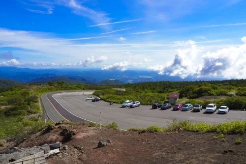
- Zao Highline (Toll Road): Branching off near Katta Pass at the top of the Echo Line, this short toll road leads directly to the Mount Katta Summit Parking Lot, putting you just steps from the main crater viewing deck.
Must-See Overlooks & Alpine Attractions
- Zao Snow Walls (Yuki-no-Kabe): Following the spring reopening of the Zao Echo Line in late April, vehicles drive between carved snowbanks reaching up to 9 meters high. A special pedestrian “Snow Wall Walk” event takes place in mid-April prior to general traffic opening.
- Takimi Lookout (Takimidai): Located along the lower Zao Echo Line (700m elevation), offering dramatic views of Fudo Falls (53.5m drop) and Sankai Falls (181m drop).
- Komakusa Taira: A cliffside overlook featuring sweeping views of Furiko Falls and dense colonies of blooming Komakusa (alpine bleeding-hearts) from mid-June to July.
- Zao Ropeway Summit Trail: For travelers approaching from Zao Onsen, take the Zao Ropeway up to Jizo Sancho Station. From there, follow a rewarding 90-minute alpine trail across Jizo Peak and Mt. Kumanodake directly to Okama Crater Lake.
Planning to drive across Mount Zao? Check out our complete Zao Echo Line Driving Guide: Scenic Spots & Snow Wall for parking details, local waterfall legends, and recommended road trip stops.
2. Hiking & Trekking Around the Rim
Exploring on foot is the best way to witness the lake from multiple dramatic angles:
- Mt. Kattadake Summit Trail (刈田岳ハイキングコース): Beginner / ~20 mins one-way
- A short, manageable walk from the summit parking lot leading up to Mt. Kattadake (1,758m) and Kattadake Shrine (Okumiya). Ideal for quick visits and sweeping views.
- Kumanodake Ridge Trek (熊野岳トレッキング): Intermediate / ~2 hours round-trip
- Follow the Umanose ridge trail across volcanic terrain to Mt. Kumano (1,840m). This route offers dynamic side-profile views of Okama Lake below framed by the surrounding volcanic landscape.
3. Viewing Deck, Trails & Alpine Flora
One of Okama Crater Lake’s greatest draws is its exceptional accessibility, catering to both casual travelers and active hikers:
- 5-Minute Walk to Views: From the Mount Katta Summit Parking Lot, a smooth, 5-minute walk brings you directly to the Goshiki-dake Observation Deck for panoramic views of the crater set against the backdrop of the Hundred Famous Mountains of Japan.
- 40-Minute Rim Hike: Visitors looking for varied angles can take the surrounding walking trail around the crater rim. Wear sturdy footwear, as the paths feature loose volcanic rock and uneven terrain.
- Summer Alpine Blooms: From early to mid-summer, delicate alpine flowers like Komakusa (alpine bleeding-heart, 駒草) bloom along the rocky mountain slopes.
Monthly Temperature Chart (Summit Level: April–November)
Because there are no tall trees along the crater rim to block exposure, wind chill significantly lowers the felt temperature. Review average monthly temperatures before packing:
| Month | Avg. High | Avg. Low | Weather & Trail Conditions |
| April | 7°C (45°F) | -5°C (23°F) | Snow walls remain; freezing temperatures |
| May | 13°C (55°F) | 1°C (34°F) | Crisp spring air; lingering snow patches |
| June | 17°C (63°F) | 6°C (43°F) | Cool alpine breezes; early bloom season |
| July | 20°C (68°F) | 10°C (50°F) | Mild summer days; summit wind chill remains |
| August | 21°C (70°F) | 11°C (52°F) | Peak summer; cool relative to lowlands |
| September | 16°C (61°F) | 6°C (43°F) | Crisp autumn air; early foliage shifts |
| October | 10°C (50°F) | -1°C (30°F) | Cold autumn temperatures; freezing winds |
| November | 3°C (37°F) | -10°C (14°F) | Early winter icing; road closure season begins |
The Visibility at Okama Crater Lake Is Only 30%? Tips for Spotting the View
Okama Crater Lake is famous for being a place where catching a clear view feels like a stroke of pure luck. Situated at an elevation of roughly 1,600 meters, mountain weather changes rapidly. Even on a bright, sunny day, thick blanket fog can roll in out of nowhere. Media reports and Japanese travel features often note that the average visibility rate for viewing the crater lake is around 30%.
If seeing Okama in all its vibrant beauty is at the top of your travel wishlist, understanding how season, time of day, wind direction, and cloud movement affect visibility is essential for beating the odds.
1. Seasonal Visibility: Summer Fog vs. Autumn Clarity
- Summer (July – August): High Fog Risk
- As warm, moist air collides with the Zao Mountain Range, dense mist forms quickly along the slopes. It is not uncommon for summer days to bring long stretches of near-zero visibility. You might pull into the parking lot under blue skies, only to reach the observation deck minutes later to find the crater entirely whiteout—with only the sound of mountain wind echoing through the mist.
- Autumn (September – October): Best Viewing Window
- As autumn brings drier air, the chances of heavy fog drop significantly. The crisp atmosphere makes September and October the best months to catch the lake’s radiant emerald-green waters under clear skies.
2. How Wind Direction Affects Your View
Because Okama is sheltered inside a deep volcanic rim, local wind patterns play a massive role in clearing out fog:
- Westerly Winds (Favorable): Strong winds from the west help push lingering mist out of the crater basin, quickly opening up clear views.
- Easterly Winds (Unfavorable): Winds from the east tend to trap cloud cover inside the crater walls, causing fog to hover for extended periods.
3. Best Time of Day to Visit Okama Crater Lake
| Time Window | Visibility Profile | What to Expect |
| Morning (8:00 AM – 10:00 AM) | Best | If clear, sunlight strikes the water directly, bringing out the lake’s famous chameleon-like color shifts. |
| Midday (11:00 AM – 2:00 PM) | Unpredictable | Rising daytime temperatures cause cloud cover and heat mist to build up rapidly over the peak. |
| Late Afternoon (3:00 PM – 5:00 PM) | High Chance of Clearing | Midday fog often begins to disperse as temperatures cool, turning the lake a deep, moody blue in the evening light. |
Patience Pays Off: A Visitor’s Experience
The unpredictable weather is precisely what makes seeing Okama so rewarding. On days when morning fog completely obscures the crater, heading back down to explore nearby sites and returning around 3:00 PM often pays off. As the wind clears the mist, the rugged, reddish crater walls and brilliant green water can reveal themselves in a single breathtaking moment.
By understanding Mount Zao’s weather patterns and picking your viewing window strategically, you can drastically boost your chances of witnessing Okama Crater Lake in all its glory.
Is Okama Lake Visible Today? How to Check Zao Live Cameras
Because Okama Crater Lake sits at high altitude, weather conditions shift rapidly and heavy alpine fog frequently blankets the caldera, even when the base of the mountain is perfectly clear. Checking real-time live cameras before setting off is essential to avoid arriving at a fogged-out summit.
The official Ministry of Land, Infrastructure, Transport and Tourism (MLIT) 24-Hour Live Camera provides real-time, high-definition video feeds of the summit crater area.
- 24/7 High-Definition Footage: Assess visibility conditions around the clock, even before sunrise.
- Road & Weather Monitoring: Spot sudden fog, heavy rain, or early seasonal snow cover along the Zao Echo Line.
- Wind & Mist Tracking: Observe how fast clouds move to gauge whether mist is likely to clear soon.
- Rapid Safety Updates: MLIT feeds update faster than general tourism boards during sudden weather changes or road closures.
4-Step Checklist: Is Okama Lake Visible Right Now?
Before deciding whether to make the drive or take the summit bus, evaluate the live camera feed using these key indicators:
- Water Surface Clarity: Can you see the distinct turquoise surface of the lake?
- Mist Movement: Is fog actively moving across the frame (indicating wind that may clear the view soon)?
- Crater Wall Definition: Are the sharp, rocky outlines of the volcanic rim clearly defined?
- Cloud Density: Is the frame filled with thin, transient mist (which often clears quickly) or a dense gray cloud bank?
Checking these details takes only a minute and ensures you don’t spend hours traveling to Mount Zao only to encounter a wall of white mist. Always review the feed right before heading up the Zao Echo Line.
How to Handle Fog & Weather Shifts on the Day
It is common for the summit to be shrouded in mist despite clear weather forecasts at lower elevations. Rather than relying on luck, follow this simple routine:
- Verify Conditions First: Always check live feeds and transit notices before heading up the mountain.
- The 10–30 Minute Rule: If the summit is foggy upon arrival, wait 10 to 30 minutes at the Summit Rest House. Mountain winds frequently clear the caldera in brief, stunning windows.
- Know When to Pivot: If visibility does not improve after a short wait, switch to an alternative lowland itinerary rather than waiting indefinitely.
The 3 Best Okama Lake Viewpoints
Whether you want an easy, accessible walk or an immersive ridge hike, three distinct viewing areas offer changing angles of the iconic volcanic crater:
| Viewpoint | Walking Time & Distance | Access & Trail Conditions | Unique Highlights |
| Main Observation Deck (展望台) | 2–3 mins (from parking lot) | Paved & fully accessible (wheelchair/stroller friendly) | Step-free access, panoramic lake view, adjacent to summit rest house |
| Mt. Kattadake Summit (刈田岳山頂) | 10 mins (from Observation Deck) | Paved gravel incline (moderate slope) | Home to Kattamine Shrine Okumiya (刈田嶺神社奥宮); offers higher top-down perspective |
| Umanose Ridge Trail (馬の背(熊野岳)) | 45 mins (one-way to Mt. Kuma junction) | Unpaved volcanic stone trail (hiking gear required) | Side-angle crater views; options to continue to Mt. Kuma (1,840m) |
1. Main Observation Deck (Easy Access & Rest House)
Located just 2 to 3 minutes from the Zao Katta Summit Parking Lot (蔵王苅田駐車場) via a wide, paved walkway, the main deck is suitable for families with young children, seniors, and visitors using wheelchairs.
However, please note that the summit can be windy, making hats prone to blowing away (a chin strap is recommended), and children can easily lose body heat.
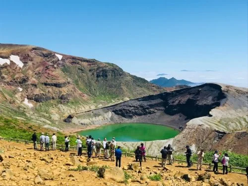
- Facilities: Features indoor glass viewing areas, a cafeteria, and local souvenir shops inside the Zao Summit Rest House.
- Suggested Stay:
- 20–30 minutes for a quick viewing
- 45–90 minutes to enjoy lunch
- 90~ minutes if waiting out passing fog for photography (the key is to set a “maximum waiting time”).
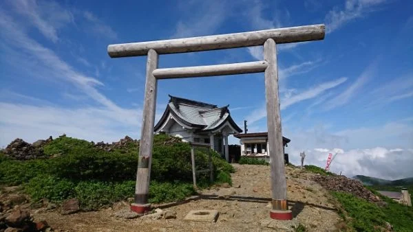
2. Mt. Kattadake Summit (1,758m) & Kattadake Shrine
A gentle 10-minute walk up a gravel incline from the main deck brings you to the summit of Mt. Kattadake.
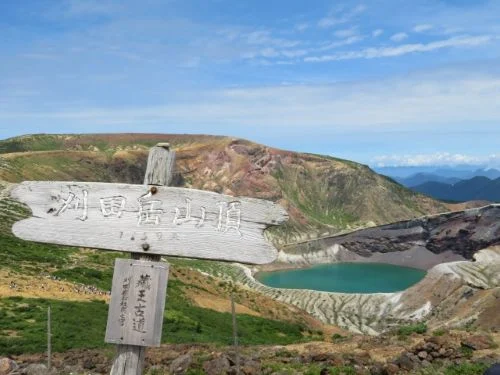
The Zao mountain range, including Mount Katta, was once feared as a place of fire-spewing peaks. Believing that all natural phenomena were the work of divine power, people built Kattamine Shrine (刈田嶺神社) to appease the gods. However, heavy snowfall in winter made it difficult to visit the shrine.
To address this, the “Satomiya” (Village Shrine, 里宮) of Kattamine Shrine was built at the foot of the mountain in Toogatta Onsen (遠刈田温泉), allowing people to worship there even during the winter months.
- Kattadake Shrine (Okumiya): Perched at the peak, this historic shrine enshrines Amo-no-Mikumari-no-Kami (国之水分神) and Kuni-no-Mikumari-no-Kami (国之水分神), two water deities worshipped to calm volcanic activity.
- Goshuin Seals: Visitors can obtain seasonal Goshuin temple stamps (¥300) and commemorative stamp books featuring Okama Lake designs (¥1,200) from both Okumiya and Satomiya. In winter, worship shifts to the Satomiya shrine in Toogatta Onsen below.
3. Umanose Ridge Trail & Mt. Kumano (1,840m)
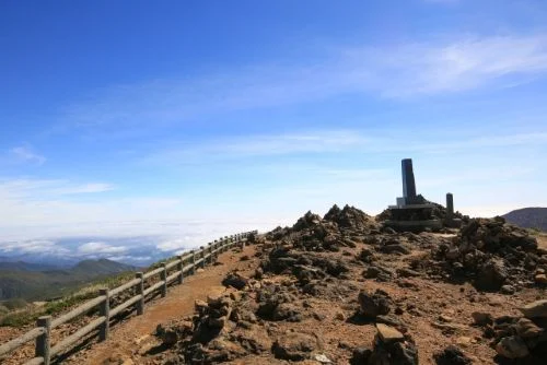
Extending along the outer volcanic rim, the Umanose Ridge Trail (馬の背) connects the crater area to Mount Kumanodake (熊野岳), the highest peak in the Zao range. This 1-hour ridge hike (~2 km one-way) follows the edge of the caldera, offering what is arguably the single best vantage point for taking in full side-profile views of Okama’s rugged walls and emerald waters.
Hike Highlights & Cultural Landmarks
- Dynamic Side-Profile Views: Walking along the rim highlights the dramatic, sheer crater walls framing the turquoise lake below.
- Alpine Blooms (June–July): Patches of rare Komakusa (alpine bleeding-heart) bloom in the loose volcanic soil alongside the trail.
- Panoramic Summit Views: On clear days, the peak of Mt. Kumano offers views extending across to the Asahi (朝日連峰), Iide (飯豊連峰) mountain ranges on the west, alongside Mt. Jizo (地蔵山), Mt. Gassan (月山) Mt. Chokai (鳥海山) to the north.
- Kumano Shrine & Cultural Monument: At the summit of Mt. Kumano, visit Kumano Shrine (Zao-san Jinja, 蔵王山神社) and a stone monument engraved with a poem by famed Japanese poet Mokichi Saito (斎藤茂吉).
Chairlift Access Point: About 10 minutes into the trail from the summit rest house, you will pass the upper station for the Katta Chairlift (which connects down to the Katta Parking Lot on the Zao Echo Line).
Alpine Safety Warning
- Footwear & Gear: The trail consists of loose, uneven volcanic rock. Sturdy hiking shoes, windproof layers, and rain gear are essential.
- Rapid Weather Changes: Dense alpine fog can roll in within minutes, completely obliterating trail visibility (“whiteout” conditions). Stay alert to sudden cloud movement and stay on the marked path.
Zao Summit Rest House (県営 蔵王山頂レストハウス): What to Eat & Buy
Located right next to the Katta Summit Parking Lot at an elevation of roughly 1,600 meters, the Miyagi Prefectural Zao Summit Rest House serves as the primary visitor center and shelter for tourists and hikers exploring Okama Crater Lake.
Tip: If Okama Crater Lake is covered in dense fog when you arrive, don’t give up right away! Mountain weather and wind patterns shift rapidly at high altitudes, and heavy fog can often clear out unexpectedly within 20 to 30 minutes.
2nd Floor: Zao Summit Restaurant & Local Specialties
The second-floor restaurant provides a warm, comfortable space to enjoy lunch with views of the surrounding peaks.
- Menu Highlight: “JAPAN X Kama Katsudon” (Non-Vegetarian): The rest house’s famous signature dish is a heavy stone-pot rice bowl served with a 150g crispy pork cutlet and egg, designed to visually mimic the crater lake. While highly popular among local meat-eaters, this dish is not vegetarian-friendly as it contains pork and savory meat broth.
- More “Vegetarian-Friendly” Meal Options: For vegetarians, options like Kitsune Udon (noodles topped with seasoned fried tofu) or simple hot noodle soups can be requested.
- Note: Traditional Japanese noodle broths frequently use fish stock (dashi), so travelers following a strict vegetarian or vegan diet should confirm broth ingredients with the restaurant staff before ordering.
- Sweets & Desserts: Treat yourself to rich Zao rare cheesecake or soft-serve ice cream after your meal.
1st Floor: Snacks, Souvenirs & Rest Area
The first floor functions as a full-service visitor hub:
- Warm Tama Konnyaku: If summit winds chill your trip, stop by the first-floor snack counter for savory Tama Konnyaku (skewered koku-jelly balls simmered in soy sauce broth). It is a local staple and a quick way to warm up.
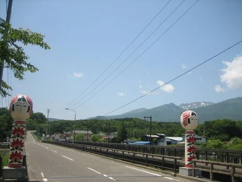
- Gift Shop & Exclusive Souvenirs: Browse a wide selection of regional crafts and local Miyagi specialty foods, including limited-edition summit Kokeshi wooden dolls available exclusively at this shop.
- Essential Amenities: The floor also provides clean public restrooms, a climate-controlled free resting lounge, and weather advisory displays.
Seasonal Attractions & Trekking Beyond Okama Crater Lake
While Okama Crater Lake is Mount Zao’s signature landmark, the surrounding slopes offer incredible seasonal experiences year-round. From sprawling spring flower festivals and vibrant autumn marshland hikes to world-famous winter snow monsters, taking time to explore beyond the crater rim unlocks the full beauty of the region. Here is what you can discover across Mount Zao throughout the changing seasons.
Spring: Miyagi Zao Eboshi Daffodil Festival (みやぎ蔵王えぼし) / Suisen Matsuri (すいせん祭り)
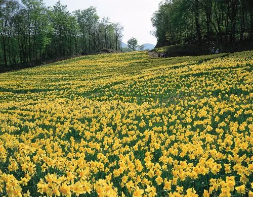
When the Zao Echo Line reopens every spring, the slopes of Miyagi Zao Eboshi Resort (みやぎ蔵王えぼしリゾート) transform into a vibrant sea of over 600,000 daffodils spanning 30 different varieties. Visitors during the annual Daffodil Festival can take a scenic chairlift ride to enjoy sweeping aerial views over the golden flower fields.
- Best Viewing / Festival Period: Late April to mid-May (varies based on blooming status)
- Location: Togatta Onsen, Zao Town, Katta District, Miyagi Prefecture
- Access: ~30-minute drive from Murata I.C. on the Tohoku Expressway
- Parking: Free during the green season (April 1 – November 28); 3,000 spaces available
Summer to Autumn: Beginner Trekking Courses on Mount Zao
Starting from the Zao Ropeway (Zao Sanroku Station, 蔵王山麓駅) on the Yamagata side, several well-maintained trails offer accessible ways to explore the alpine environment. Here are four beginner-friendly trekking routes:
1. Iroha Numa Marshland Course (いろは沼コース): 1 Hour / ~2.5 km
- Route: Take the Zao Ropeway (蔵王ロープウェイ) to Juhyo Kogen Station (樹氷高原駅), then transfer to the Utopia No. 1 Summer Chairlift (ユートピア第1夏山リフト, ~5 minutes). From the top lift station, walk 300 meters to reach Iroha Numa Marshland (いろは沼) at 1,430m elevation.
- Highlights: A raised wooden boardwalk loops around the wetland, which is filled with blooming alpine flora in summer and turns into a striking golden grass-foliage landscape (Kusa-momiji) in autumn.
- Flower Bloom Schedule:
- Pogonias & Dragon’s Mouth Orchids (Tokisou / Sawaran, トキソウ・サワラン): Mid-July
- Cottongrass (Watasuge, ワタスゲ花): Flowers in July; fluffy seed heads in mid-August
- False Hellebores, Bog Asphodel, Sundews, Plantain Lilies & Burnets (コバイケイソウ・キンコウカ・モウセンゴケ・タチギボウシ・シロバナトウウチソウ): July – August
2. Zao Botanical Garden Loop (蔵王自然植物園一周コース): 30 Minutes
- Route: Ride the Zao Ropeway up to Jizo Sancho Station (地蔵山頂駅); the garden trail begins right near the exit.
- Highlights: Passes over the peak of Mt. Sampō Kōjin (三宝荒神山) for panoramic mountain views.
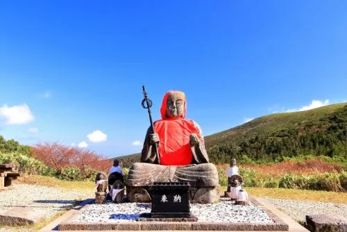
- Landmark: Marked by the giant Zao Jizo Statue (蔵王地蔵尊) at the entrance. In winter, snow buries the statue up to its neck, making summer and autumn the only seasons to view the full 2.3-meter figure!
3. Shiginoyachi Numa Pond Loop (鴫の谷地沼): 1 Hour
- Route: The only course in this list that does not require a ropeway ticket.
- Walk from Zao Sanroku Station (蔵王山麓駅) through a Asian skunk cabbage colony (Mizubasho (ミズバショウ), blooming late April onwards) to loop around Shiginoyachi Numa Pond.
- Highlights: Highly popular during autumn foliage season when photographers gather to capture the colorful mountain reflections on the water’s surface.
4. Mt. Jizo Summit Loop (地蔵山周遊コース): 1.5 Hours
- Route: Depart from Jizo Sancho Station (地蔵山頂駅) and follow the summit trail up to Mt. Jizo (地蔵山) at 1,736m elevation.
- Highlights: Sweeping high-altitude vistas alongside unique historic trail markers, including a weathered stone statue of Ubagami (姥神), the mountain guardian goddess.
Winter: Zao Snow Monsters (Juhyo, 樹氷)
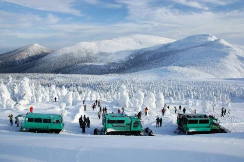
In winter, Mount Zao is famous worldwide for its “Snow Monsters” (Juhyo), a rare natural phenomenon caused by supercooled water droplets freezing onto evergreen trees, found in only a handful of locations across Japan and the world.
Planning Note: Snow monster viewing is accessible from both the Yamagata and Miyagi sides, but access routes, transport methods, and viewing setups differ significantly.
Nearby Attractions & Sendai Day-Trip Itineraries
To maximize your Mount Zao excursion, combine your visit to Okama Crater Lake with nearby cultural highlights, historic hot springs, and structured day-trip routes departing from Sendai.
Recommended Attractions Near Okama
- Zao Onsen (蔵王温泉): Located on the Yamagata side, this historic hot spring village is famous for its highly acidic, sulfur-rich thermal waters that are revered for skin rejuvenation.
- Zao Fox Village (宮城蔵王キツネ村): Situated in Shiroishi, Miyagi Prefecture, this unique sanctuary allows visitors to observe over 100 free-roaming foxes in a open forest environment.
- Regional Tohoku Cuisine: Sample local specialties at mountain rest houses, including Imoni (a savory taro and beef soup native to Yamagata) and Zunda Mochi (sweetened crushed edamame rice cakes).
3 Sendai to Mount Zao Day-Trip Itineraries
If you are using Sendai as your base, these three sample driving itineraries help balance summit visibility, travel pace, and backup plans:
Course 1: The “Morning First” Visibility Route (Best for Clear Crater Views)
- Strategy: Ascend early to capture optimal summit visibility and beat peak road congestion.
- 08:00 AM: Depart central Sendai early by rental car.
- 09:00 AM: Pass through Togatta Onsen at the base of the mountain.
- 09:30–10:00 AM: Arrive at Katta Summit Parking Lot; explore the observation deck before crowds arrive.
- 10:30–11:30 AM: Take a break at the summit rest house and begin descending.
- 12:00–01:00 PM: Lunch at the base of the mountain or return to Sendai.
- Best For: First-time visitors, photographers, and travelers wanting to avoid traffic.
Course 2: Summit Views & Togatta Onsen Relaxation
- Strategy: Pair high-altitude sightseeing with a soothing hot spring soak at the foot of the mountain.
- Morning: Ascend to Okama Crater Lake (aim to arrive around 10:00 AM).
- Mid-Day: Descend to Togatta Onsen (遠刈田温泉) at the mountain base for lunch and a day-use hot spring (hitori-guri) bath.
- 03:00–04:00 PM: Enjoy a relaxed drive back to Sendai before evening peak hour.
- Best For: Drivers looking to unwind, couples, and leisure travelers.
Course 3: Fog Backup Route (Weather-Proof Day Trip)
- Strategy: Protect your itinerary satisfaction even if mountain fog blankets the summit.
- Summit Strategy: If webcams or arrival conditions show total fog, set a strict 30-minute waiting limit at the rest house.
- Alternative Pivot: If the fog does not clear, pivot downhill to valley attractions along the Zao Echo Line (Takimi Lookout waterfalls, local cafes, craft shops, or Togatta Onsen).
- Best For: Flexible travelers ensuring a fun day out regardless of mountain weather.
Exploring Sendai: Best Things to Do Before or After Mount Zao
Planning to use Sendai as your base for visiting Mount Zao? As Miyagi Prefecture’s capital, Sendai offers the fastest transit connections to Okama Crater Lake via the Shiroishi-Zao Shinkansen and seasonal mountain buses, making it the ideal launching pad for a day trip.
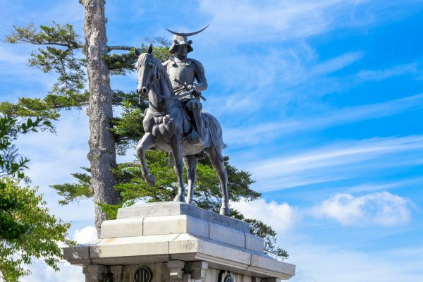
Before heading up the mountain pass, check out our Ultimate Travel Guide to Sendai: The City of Trees to explore historic Date Masamune castle sites, vibrant shopping arcades, and seamless regional transit routes.