Shimoji-Shima Island (下地島) is one of the eight islands in Miyakojima City. Having one of the only two airports located on the island and with the completion of the 3,540-meter-long Irabu Bridge, Shimoji-Shima is the next most accessible island in the city after Miyako Island. Although its size isn’t the biggest in the region, Shimoji Island has a few natural attractions you won’t want to miss out on when you visit this part of Okinawa!
Read on and discover the hidden gems in Miyakojima City!
Table of Contents
- How to Get to Shimoji-shima
- Miyako Shimojishima Airport (みやこ下地島空港)
- 17END (ワンセブンエンド)
- 35END (サンゴエンド)
- Tōriike Pond (通り池)
- Shimoji Island Monolith (下地島巨石)
- Nakanoshima Beach (中の島ビーチ)
How to Get to Shimoji-shima
There are a few ways to access Shimoji Island, including flying into the island. You can also cross the Irabu Bridge by bus or drive a car from Miyako Island.
Miyako Shimojishima Airport (みやこ下地島空港)
Originally a training airfield for commercial pilots, Miyako Shimojishima Airport was transformed into a tropical-resort-style airport in 2019.
As soon as you land, you can already feel the holiday vibe as you walk inside the cedar wood building. And if this is the last stop of your journey, waiting for boarding at the hotel reception-like lobby would probably be the best way to enjoy every last minute of your trip (^_-)-☆.
If you need more of Miyakojima’s delicious tropical fruits, the cafes at Miyako Shimojishima Airport have got you covered! The local specialties are sold at the airport, allowing you to complete some last-minute shopping.
Tip: The seafront view from Shimojishima Airport is best around noon.
If you don’t plan on driving during your time in Miyakojima City, you can take Miyako Kyōei Bus’ (宮古協栄バス) Shimoji Airport Resort Line (下地島空港リゾート線) to get to Irabu Island and Miyako Island.
- Refer to HERE for the service’s timetable. You can translate it into English using Google Chrome’s translation function at the right of the address bar.
- You can also use one of Japan’s Transport Apps to plan your visit.
17END (ワンセブンエンド)
The best photogenic beach on Shimoji Island has to be 17END, which spreads under the road surrounding the runway of Shimojishima Airport. At low tide, the sandy beach appears, and the stunning shallow blue sea spreads!
The only con of 17END is the lack of coral reefs. And because of this, the beach is more like a swimming pool with crystal-clear water.
For more information, refer to our article on 17END!
35END (サンゴエンド)
While 17END isn’t a hidden gem anymore, its counterpart, 35END, remains unknown by many. Like 17END, the number 35 is an aviation term indicating 350 degrees. But this time, the south is zero degrees. 35END is thus the spot on the south end of the Shimojishima Airport’s runway.
Unlike 17END, a vast beach, 35END is more of a cove with a small sandy shore. Because 35 can be pronounced as “Sango (珊瑚)” in Japanese, which can mean coral reef, the cove is nicknamed Coral Reef End (珊瑚エンド).
In fact, there are coral reefs at 35END, making it not just a pun but worthy of its nickname, thus a spot more suitable for diving and snorkeling.
Tip: In winter or during the north wind, airplanes would land from this part of the runway.
Tōriike Pond (通り池)
On Shimoji-Shima Island, there are two round ponds with colors changing by the tidal conditions. The ponds were formed by seawater erosion of the limestone layer. Because they are connected with the sea, don’t be surprised if you see people popping out of the pond!
For more information, refer to our article on Tōriike Pond!
Shimoji Island Monolith (下地島巨石)
As you travel south from Tōriike Pond, you will encounter one of the largest rocks washed up by a tsunami!
The gigantic 12.5-meter tall rock known as Shimoji-Shima Obi Stone (帯石) was brought onshore from the sea by the Great Tsunami of Meiwa (明和の大津波) caused by the Yaeyama Great Earthquake (八重山地震) in 1771. More than 12,000 people perished or were washed away. The Shimoji Island Monolith is there as a reminder to all of us of how powerful nature can be.
The cliff behind Obi-iwa is at least 15 meters tall. So the tsunami would have to reach a height taller than the cliff to bring Obi-iwa to where it is now. Knowing this, it isn’t hard to imagine why there were no traces left of the village prior to the earthquake. According to Tōriike Pond’s mermaid folktale, it was said that the earthquake was brought by the anger of the spiritual creatures to save their fellow.
This type of rock is called Tsunami-ishi (津波石) or Tsunami-iwa (津波岩) in Japanese because they are a product of the tsunami. Shimoji Island Monolith is larger than the Tsunami-iwa Rock at Miyako Island’s Cape Higashi-Hennazaki. In fact, it is the largest Tsunami-ishi in Japan!
Since it was washed up, the rock has been treated as an object of worship. The locals would pray to the rock for a good fish catch, a safe sail, and the well-being of their family members.
So why did the locals name it Obi? If you look at one side of the rock and then look at someone who is in a kimono, you will notice that the middle part of the rock looks like a kimono obi belt (^_-)-☆.
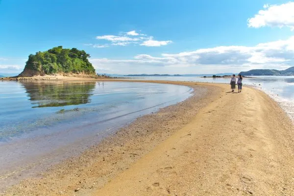
Nakanoshima Beach (中の島ビーチ)
Amongst all the beaches on Shimoji-Shima and Irabu Island, Nakanoshima Beach is the representative spot for snorkeling and diving. With many coral reefs spreading across Nakanoshima Beach, a variety of species of tropical fish reside there, known as the natural aquarium.
The beach that is also known as Kayaffa Beach (カヤッファビーチ) is usually unaffected by the sea concision in the open sea. So even snorkeling beginners can enjoy the underwater world in the bay up to four-meter in depth! And if you are relatively experienced, hop onto a boat to the offshore area where you can dive as deep as 10 meters.
Even if you choose to stay on shore, the cobalt-blue sea is so clear that you can still enjoy the scenery without getting wet. Occasionally, there might even be airplanes flying over your head (^_-)-☆.
Furthermore, you can have a little adventure exploring the rocky area on the beach’s right. See if you can find a penetrative cave leading to the bay next door!
Important:
☛ If you want to snorkel, it is best to come fully prepared. While there are usually mobile rental shops around Nakanoshima Beach, there aren’t permanently stationed there.
☛ There is no toilet or shower facility around. However, you can fill several water bottles with tap water beforehand to quickly wash off the sand and salt after coming up from the beach.
☛ Instead of sandals, marine shoes are recommended to protect your feet from the occasionally sharp rocky surface.
☛ The beach’s depth can get a lot deeper as you swim away from the shore. Also, the current’s speed is generally a lot faster around high tides.
Tip: You can ask the hotel reception to reserve one of the diving or snorkeling tours for you.
How to Get to Nakanoshima Beach
- It is around a 7-minute drive from Shimojishima Airport and a 30-minute drive from Miyako Airport.
- The parking space across the road from Nakanoshima Beach has a capacity of around 20 cars, which can be pretty packed between July to September by noon.
Discover the Astonishing Places to Visit on Irabu Island
Irabu Island is an island that goes hand in hand with Shimoji Island when you visit Miyakojima City. It is much larger and has many more stunning beaches and natural spots that you might want to visit.
Refer to our Irabu Island article to find out what they are!
Discover Other Awesome Attractions in Miyakojima City
Obviously, Shimoji shouldn’t be the only island to visit when you head to Miyakojima. So if you are unsure where else is worth your time, our Top 12 Attractions in Miyakojima City article can provide you with some ideas!