If you are looking for off-the-beaten-path destinations in the Kansai region, head to Yabu City in Hyōgo Prefecture. The city is perfect for outdoor recreation activities. It also has some amazing scenery that will captivate you any time of the year!
A List of Attractions in Yabu City
- Yabu Shrine (養父神社)
- Togayama Onsen Tennyo no Yu (とがやま温泉 天女の湯)
- Firefly Village – Hotaru no Sato (ほたるの里)
- Tarumi no Ōzakura (樽見の大桜)
- Tendaki Falls (天滝)
- Mt. Hyōno (氷ノ山)
- Bekkū Rice Terrace (別宮の棚田)
- Hachi Kōgen (ハチ高原)
- Torokawa Valley (瀞川渓谷)
- Akenobe Mine (明延鉱山)
Yabu City Sightseeing Taxi (養父市 定額観光タクシー)
As a city in a rural area, some of the attractions below are harder to get to by public transport. So if you want to get there quickly, consider renting a car. If you don’t want to drive, hop into a sightseeing taxi instead!
What is great about the sightseeing taxi is its flexibility. Furthermore, you won’t be charged for the distance traveled. Instead, you pay by the hour.
A 5-seater taxi starts with a minimum of 2 hours and a maximum of 6. It currently costs 2,500 yen per hour. Going beyond 6 hours is not recommended, as you will be charged by distance traveled.
Reservation is required at least 5 days in advance by emailing [email protected]. You can also book by calling them if you speak Japanese.
For more information, please refer to the bottom of the official access page HERE.
Yabu Shrine (養父神社)
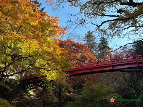
Yabu Shrine is one of the most popular autumn foliage destinations in Yabu City. The shrine built in 737 is one of the top five shrines in Tajima Province (但馬).
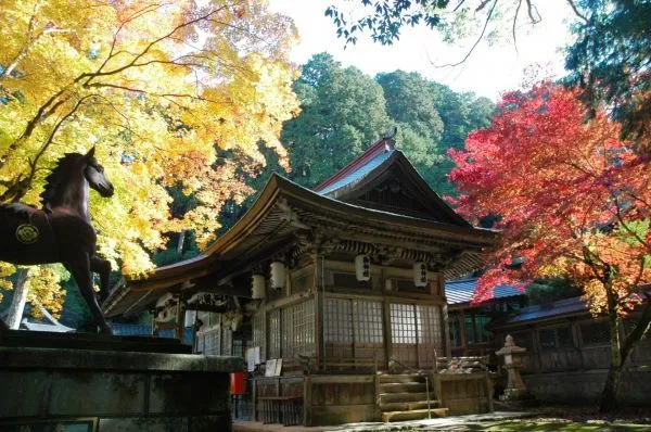
The gods of Yabu Shrine look after agricultural and sericultural activities. This is why on top of the stone lion-dog statues, Komainu (狛犬), common in Japanese shrines, there are also statues of wolves as the shrine’s guarding animals.
Why wolves? It is because they hunt animals that are likely to ruin paddy and/or vegetable fields, such as wild boars and deer.
From late October, the color of the maple leaves starts to change. The autumn foliage season usually peaks from early to mid-November each year. It is also when the Yabu Momiji Festival (やぶ紅葉まつり) is held.
In 2022, the festival was held from the 4th to the 26th of November. Nighttime illumination is from sunset to 8 pm if it isn’t raining.
You can also refer to the official website HERE for future festival dates. Utilize Google Chrome’s translation function at the right of the address bar to translate the webpage to English.
Tip: The best spot to adore the autumn foliage at Yabu Shrine is probably from the shrine’s car park, underneath the red bridge of the shrine. The view is astonishing!
How to Get to Yabu Shrine
From JR Yabu Station (養父駅), take the Zentan Bus (全但バス) and get off at Yabu Myōjin (養父明神).
- Yamaguchi Ikuno Line (山口生野線)
- Yōka Takinoya Line (八鹿建屋本線)
- Yōka Wadayama Line (八鹿和田山線)
Click HERE to return to a list of attractions in Yabu City.
Togayama Onsen Tennyo no Yu (とがやま温泉 天女の湯)
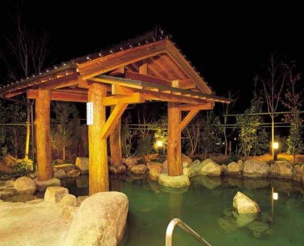
The onsen facility, not too far from most of the attractions in Yabu City, is open until 9 pm. Relaxing in the onsen pool after a day of exploration is pure bliss!
So if you want to indulge your worn-out body in a nice hot spring, consider stopping by Togayama Onsen Tennyo no Yu.
They also have a private bath you can reserve in advance. Bookings must be made by the day before your visit. Call them at +81-79-665-6677.
Togayama Onsen Tennyo no Yu’s Business Hours, Admission Fee, and Access Information
- Business hours are from 10 am to 9 pm daily except Thursdays unless it is a public holiday.
- The last admission is at 20:15 pm.
- The admission fee is
- 700 yen for adults
- 400 yen for children from 3 years old to elementary school students
- 1,000 yen per 60 minutes for a private bath
- From JR Yōka Station (八鹿駅), you can also take a bus and get off at Togayama Onsen (とがやま温泉).
Click HERE to return to a list of attractions in Yabu City.
Firefly Village – Hotaru no Sato (ほたるの里)
Besides the hot weather and typhoons, summer in Japan isn’t all that bad, especially with the fireflies dancing around in June. In Yabu City, the best place to see these little dancers is Hotaru no Sato. Although it can be difficult to travel there by public transport, it is definitely worth the effort when the weather is good!
While the fireflies won’t be active before sunset, we still recommend getting there a bit earlier to see the fireflies’ decorations on the road to the river, where the fireflies inhabit!
If you are heading there on a Saturday, Firefly Festival or Hotaru Matsuri (ほたる祭り) is probably on. This means you probably won’t be able to park at the venue between 8 and 9 pm.
But don’t worry. Fireflies should still be out after 9 pm for those who can’t get to the Firefly Village earlier (^_-)-☆.
Tip: You can also spend a night at their Hotaru no Yakata (ほたるの館). Refer to HERE for some photos. To reserve, call the facility at +81-79-665-0588.
How to Get to Hotaru no Sato
From the closest train station, no bus services stop at the nearest bus stop – Okumeiji (奥米地). So if you aren’t driving, please take a taxi from JR Wadayama Station (和田山駅). It is around a 20-minute drive.
Click HERE to return to a list of attractions in Yabu City.
Tarumi no Ōzakura (樽見の大桜)
If you plan to visit Yabu City in spring and are looking for cherry blossoms, don’t miss out on Tarumi no Ōzakura! This cherry tree, rumored to be around 1,000 years old, has a height of 13.8 meters, and a trunk circumference of about 6.3 meters Σ(゚Д゚). This National Natural Monument is currently the biggest weeping cherry tree in Hyōgo Prefecture!
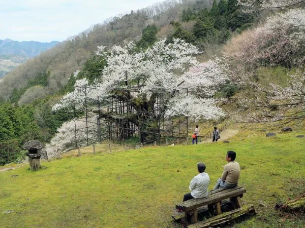
Considering it lived longer than the average lifespan of cherry trees, there was noticeable withering on the trunk and branches in 1967. The Tarumi Ōsakura Preservation Society was consequently established in 1973. A lot of work has been put into restoring the tree’s health.
Thanks to the preservation society and local volunteers, Tarumi no Ōzakura is currently in good condition producing many flowers and leaves that cover the entire tree. In addition, little cherry blossoms grow from the fruits of Tarumi no Ōzakura are around as well!
Traveling to Tarumi no Ōzakura isn’t all that easy, though. From the car park, you have got to hike up for around 400 meters. Taking breaks into account, it will probably take about 20 to 30 minutes. The parking lot can only hold around 20 cars. So on weekends, you might need to park further away, adding to the hiking time. However, cherry trees bloom along the trail, so you can hike and adore the flowers at the same time (^_-)-☆.
Before reaching the car park, you will have to drive through a narrow road about 2 kilometers long.
When Will Tarumi no Ōzakura Bloom
Tarumi no Ōzakura usually blossoms from early to mid-April each year.
Tip: Tarumi no Ōzakura is on the northwestern slope. So it will be in the shade in the early morning. Depending on what lighting you like, it might be better to come from the late morning onward.
How to Get to Tarumi no Ōzakura by Public Transport
- From JR Yōka Station (八鹿駅), take Zentan Bus (全但バス) bound for Akenobe (明延) and get off at Nakamura-shita (中村下). From there to the car park, it is a 30-minute walk.
- The bus trip is around 50 minutes
- HERE is the timetable for buses departing from JR Yōka Station
- HERE is the timetable for buses departing for JR Yōka Station
- You can also use one of Japan’s Transport Apps to plan your visit.
You can use Google Chrome to translate the timetable above.
Click HERE to get back to a list of attractions in Yabu City.
Tendaki Falls (天滝)
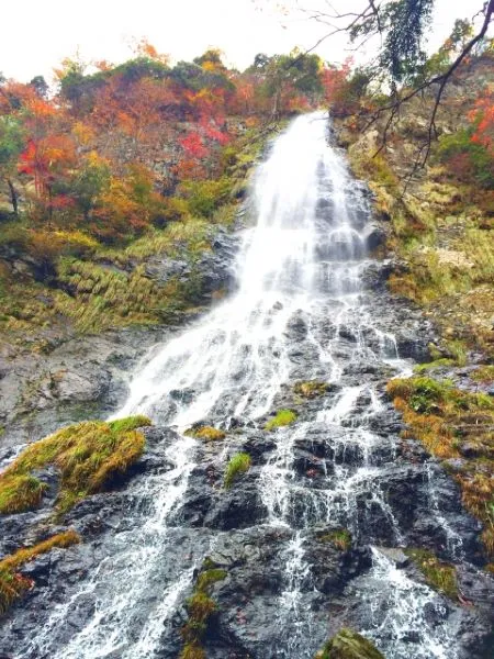
Tendaki Falls in Yabu City, with a height of 98 meters, is the best waterfall in Hyōgo Prefecture and one of Japan’s Top 100 Waterfalls! If you are coming to Japan to enjoy the stunning nature, this waterfall, surrounded by rich nature, is a perfect choice. One thing to note is that due to heavy snow in the area, Tendaki Falls isn’t accessible in winter.
It goes without saying, Tendaki Falls receives the most visitors during the autumn foliage season. Along the Tendaki Valley, the color usually peaks from early to mid-November.
If you are interested in visiting the waterfall, refer to our Tendaki Falls article for more information!
Click HERE to return to a list of attractions in Yabu City.
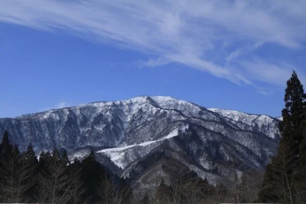
Mt. Hyōno (氷ノ山)
Mt. Hyōno (氷ノ山), with a height of 1,510 meters, is the highest mountain in Hyōgo Prefecture. The mountain blessed with an excellent natural environment was chosen as one of Japan’s 200 most famous mountains. The area is decorated with rare plants and animals, such as the National Natural Monument Golden Eagle. The Torokawa Valley (瀞川渓谷) on the western foot of Mt. Hyōno is also one of the 100 Hidden Scenic Spots in the country. In winter, the locals also visit the mountain for skiing.
For more information, refer to our Mt. Hyōno article!
Click HERE to return to a list of attractions in Yabu City.
Bekkū Rice Terrace (別宮の棚田)
On the way to Hachi Plateau or Hachi Kōgen (ハチ高原), as you come out of the forest, amazing scenery will suddenly appear.
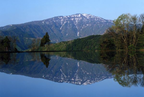
The rice terrace on the hillside of Mt. Hachibuse (鉢伏山) is situated at an altitude of 700 meters. The 130 or so rice fields color the landscape differently in each season.
To get a full view of Mt. Hyōno, Bekkū Rice Terrace is the best observatory spot. The best time for photos is at the beginning of May, when the rice paddy is filled with water, as preparation for rice planting in early May.
The scenery is known as Sakasa Hyōnosen (逆さ氷ノ山), which simply means Mt. Hyōno upside down.
The water slowly withdraws over a few days, but it will be maintained at around the same level as per the photo. So, the reflection of Mt. Hyōno can still be seen after rice planting until early June. It just means your reflection of the mountain will have many rice seedlings growing out, which can be interesting to see, too (´▽`*).
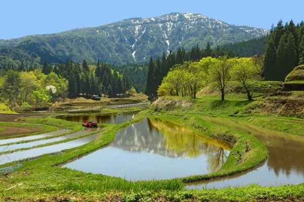
Bekkū’s Big Katsura Tree (別宮の大カツラ)
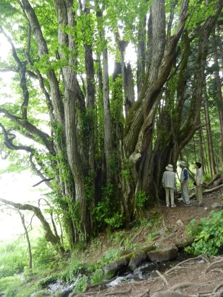
Since Bekkū Rice Paddy is in a remote region, one might wonder how the farmers source so much water.
Well, the secret lies with the huge Katsura tree over 1,200 years old!
Near the car park, the tree, with a height of 27 meters and branches stretching as far as 24 meters, is a Prefectural Natural Monument. Spring water flows from the tree’s root, moistening the rice terraces below.
According to the famous monk – Kūkai (空海), this Katsura tree is a sacred tree of water. No wonder the rice produced from the rice paddy here, known as Bekkū Tanada Rice (別宮棚田米), is extremely delicious (also due to the large temperature difference during the daytime and at night.
How to Get to Bekkū Rice Terrace
- If you are driving, there is a free car park with a capacity of 10 cars. It is also possible to park on the wide road shoulder.
- If you are taking public transport, please refer to the access information of Hachi Kōgen. Please get off at Bekkukami (別宮上) instead of Hachi Kōgen.
Click HERE to return to a list of attractions in Yabu City.
Hachi Kōgen (ハチ高原)
Driving west of Bekkū Rice Terrace, the Hachi Kōgen or Hachi Plateau, situated further up on Mt. Hachibuse (鉢伏山) at an altitude between 800 to 900 meters, is one of western Japan’s leading areas for outdoor activities.
It is great for hiking, camping, and paragliding. When the plateau isn’t covered by snow, it is the ideal escape from the hustle and bustle of the city!
If you are an experienced hiker, you can march to the summit of Mt. Hyōno from the trailhead at Hachi Kōgen.
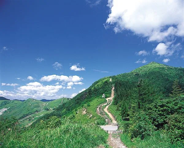
In winter, the Hachi Kōgen Ski Resort (ハチ高原スキー場) is Kansai’s largest snow park.
For more information about skiing at Hachi Kōgen, please refer to the official website HERE and change the language to English using Google Chrome’s translation function to the right of the address bar.
How to Get to Hachi Kōgen by Public Transport
From JR Yōka Station (八鹿駅), take Zentan Bus’s (全但バス) Hachifuse Line (鉢伏) and get off at Deai Terminal (出合ターミナル). From there, change for Yabu City’s Community Bus – Seki no Miya Fureai Bus (関宮ふれあいバス) bound for Hachi Kōgen (ハチ高原) and get off at Hachi Kōgen.
- HERE is the timetable for buses departing from JR Yōka Station.
- HERE is the timetable for buses departing for JR Yōka Station.
- HERE is the timetable for Seki no Miya Fureai Bus.
- This service operates only on weekdays, excluding public holidays, and from the end of December to the beginning of January.
Click HERE to return to a list of attractions in Yabu City.
Torokawa Valley (瀞川渓谷)
Just like Mt. Hyōno, Torokawa Valley, also in the Hyōnosen-Ushiroyama-Nagisan Quasi-National Park (氷ノ山後山那岐山国定公園) has such stunning scenery that it was chosen to be one of Japan’s Top 100 Hidden Scenic Spots!
For more information, refer to our Torokawa Valley article!
Click HERE to return to a list of attractions in Yabu City.
Akenobe Mine (明延鉱山)
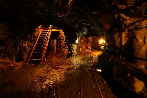
If you have ever wondered where the copper of the Great Buddha at Tōdaiji Temple in Nara was from, visit Akenobe Mine, discovered in 809!
For more information, please refer to our article on Akenobe Mine!
Click HERE to return to a list of attractions in Yabu City.
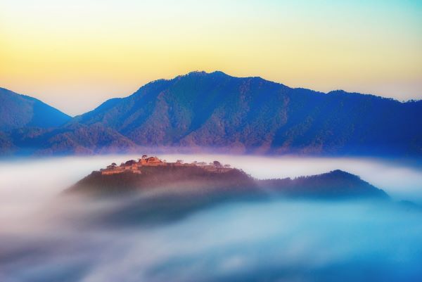
Making a Side Tour for the Castle in the Sky
The Takeda Castle in Asago City, next to Yabu City, is known as one of Japan’s Three Castles in the Sky. If you haven’t had enough spectacular scenery, how about heading to the castle after visiting Yabu City?
For more information about the amazing scenery, please refer to our article on Takeda Castle!